No higher resolution available.
Mapa_Gobernacion_de_Chile.PNG (151 × 211 pixels, file size: 10 KB, MIME type: image/png)
| This is a file from the Wikimedia Commons. Information from its description page there is shown below. Commons is a freely licensed media file repository. You can help. |
Summary
| Description |
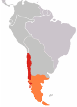
Mapa de la Gobernación o Capitanía General de Chile, según historiografía chilena. NOTA IMPORTANTE: la Patagonia Oriental de acuerdo a la Real Cédula de 1570 correspondía de derecho a la Provincia del Río de la Plata (Virreinato del Perú, posteriormente Virreinato del Río de la Plata) situación no considerada en la historiografía chilena. |
| Date | Unknown date |
| Source | Own work |
| Author | Valo3 |
Licensing
| I, the copyright holder of this work, release this work into the public domain. This applies worldwide. In some countries this may not be legally possible; if so: I grant anyone the right to use this work for any purpose, without any conditions, unless such conditions are required by law. |
File history
Click on a date/time to view the file as it appeared at that time.
| Date/Time | Thumbnail | Dimensions | User | Comment | |
|---|---|---|---|---|---|
| current | 21:01, 14 December 2022 | | 151 × 211 (10 KB) | Janitoalevic | . |
| 05:59, 29 September 2007 |  | 151 × 211 (8 KB) | Valo3 | {{Information |Description= Mapa de la Gobernación de Chile |Source=self-made |Date= |Author= Valo3 }} | |
| 05:29, 29 September 2007 |  | 236 × 331 (12 KB) | Valo3 | {{Information |Description= Mapa de la Gobernación o Capitanía General de Chile |Source=self-made |Date= |Author= Valo3 }} | |
| 05:22, 29 September 2007 |  | 236 × 331 (12 KB) | Valo3 | {{Information |Description= |Source=self-made |Date= |Author= Valo3 }} |
File usage
The following pages on the English Wikipedia use this file (pages on other projects are not listed):
Global file usage
The following other wikis use this file:
- Usage on no.wikipedia.org