
Size of this preview: 565 × 599 pixels. Other resolutions: 226 × 240 pixels | 452 × 480 pixels | 724 × 768 pixels | 965 × 1,024 pixels | 1,931 × 2,048 pixels | 13,062 × 13,856 pixels.
Original file (13,062 × 13,856 pixels, file size: 21.45 MB, MIME type: image/jpeg)
| This is a file from the Wikimedia Commons. Information from its description page there is shown below. Commons is a freely licensed media file repository. You can help. |
Summary
| Warning | The original file is very high-resolution. It might not load properly or could cause your browser to freeze when opened at full size. |
|---|
| Description |
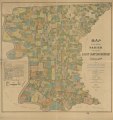
English: Shows names of some residents. "Copyright 1895 by A. Kaiser & J.A. Swensson." Copy imperfect: Mounted on cloth back and folded in half. Annotated red and black ink. "Large Roman figures indicate Ward Numbers, and small upright figures represent section numbers." Includes text and indexed map of to the city of Baton Rouge. LC Land ownership maps, 250 Available also through the Library of Congress Web site as a raster image. |
||
| Title | Map of the Parish of East Baton Rouge, Louisiana | ||
| Shelf ID | G4013.E2G46 1895 .K3 | ||
| Date | |||
| Source | https://www.loc.gov/item/2012592319/ | ||
| Author | Kaiser, A.; Swensson, J. A. | ||
| Permission (Reusing this file) |
|
||
| Other versions |
|
||
| Location | United States · Louisiana · East Baton Rouge Parish | ||
| Part of | American Memory · Catalog · County Landownership Maps · Geography And Map Division · Cultural Landscapes | ||
| Subject | Cadastral Maps · Landowners · United States · Maps · East Baton Rouge Parish · Louisiana · East Baton Rouge Parish (La.) |

Licensing
|
This is a faithful photographic reproduction of a two-dimensional, public domain work of art. The work of art itself is in the public domain for the following reason:
The official position taken by the Wikimedia Foundation is that "faithful reproductions of two-dimensional public domain works of art are public domain".
This photographic reproduction is therefore also considered to be in the public domain in the United States. In other jurisdictions, re-use of this content may be restricted; see Reuse of PD-Art photographs for details. | ||||
File history
Click on a date/time to view the file as it appeared at that time.
| Date/Time | Thumbnail | Dimensions | User | Comment | |
|---|---|---|---|---|---|
| current | 05:20, 4 June 2018 | | 13,062 × 13,856 (21.45 MB) | Fæ | LOC Maps https://www.loc.gov/item/2012592319/ #4261 |
File usage
The following page uses this file: