File:Map of the Federal Republic of Germany and Berlin (states, administrative districts), circa 1949 (175515517).png
,_circa_1949_(175515517).png)
,_circa_1949_(175515517).png&action=edit&redlink=1)

Size of this preview: 454 × 600 pixels. Other resolutions: 182 × 240 pixels | 363 × 480 pixels | 581 × 768 pixels | 775 × 1,024 pixels | 1,550 × 2,048 pixels | 3,433 × 4,536 pixels.
Original file (3,433 × 4,536 pixels, file size: 23.74 MB, MIME type: image/png)
| This is a file from the Wikimedia Commons. Information from its description page there is shown below. Commons is a freely licensed media file repository. You can help. |
,_circa_1949_(175515517).png)
Summary
| Description |
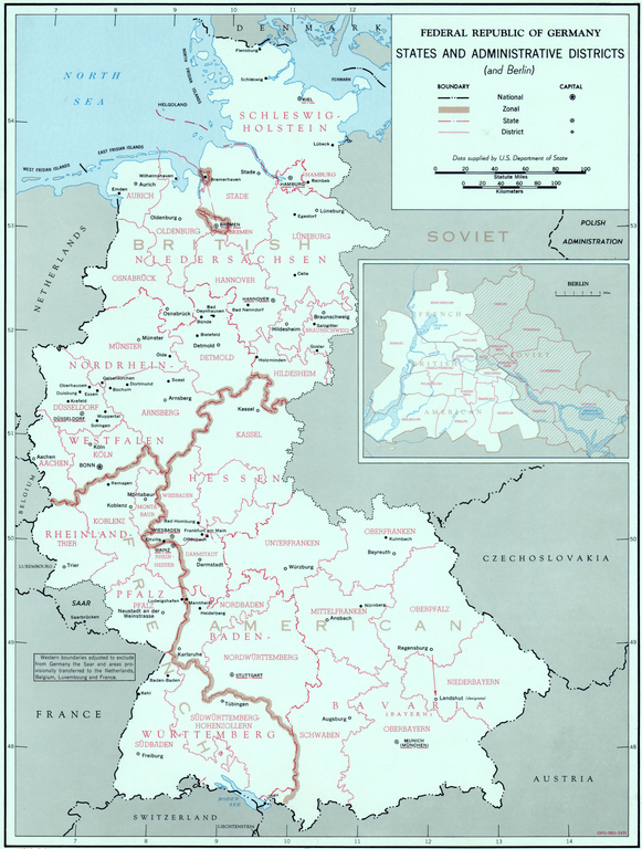
English: Map of the Federal Republic of Germany and Berlin, showing states, administrative districts (and Allied sectors), circa 1949. |
|||
| Date | circa 1949 | |||
| Source |
|
|||
| Author | U.S. National Security Council. Central Intelligence Agency. Directorate of Intelligence. Office of Basic and Geographic Intelligence. |
Licensing
| This image is a work of a Central Intelligence Agency employee, taken or made as part of that person's official duties. As a Work of the United States Government, this image or media is in the public domain in the United States.
|

|
File history
Click on a date/time to view the file as it appeared at that time.
| Date/Time | Thumbnail | Dimensions | User | Comment | |
|---|---|---|---|---|---|
| current | 20:13, 7 March 2021 | | 3,433 × 4,536 (23.74 MB) | Cobatfor | == {{int:filedesc}} == {{Information |Description={{en|1=Map of the Federal Republic of Germany and Berlin, showing states, administrative districts (and Allied sectors), circa 1949.}} |Source={{NARA-image|id=175515517}} |Date={{other date|ca|1949}} |Author=U.S. National Security Council. Central Intelligence Agency. Directorate of Intelligence. Office of Basic and Geographic Intelligence. |Permission= |other_versions= }} =={{int:license-header}}== {{PD-USGov-CIA}} [[Category:Maps of the h... |
File usage
The following pages on the English Wikipedia use this file (pages on other projects are not listed):
,_circa_1949_(175515517).png)