
Size of this PNG preview of this SVG file: 297 × 406 pixels. Other resolutions: 175 × 240 pixels | 351 × 480 pixels | 562 × 768 pixels | 749 × 1,024 pixels | 1,498 × 2,048 pixels.
Original file (SVG file, nominally 297 × 406 pixels, file size: 68 KB)
| This is a file from the Wikimedia Commons. Information from its description page there is shown below. Commons is a freely licensed media file repository. You can help. |
Summary
| Description |
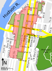
Current district |
| Date | |
| Source | SVG version of File:Central Troy Historic District map.png. Red boundaries based on this map, and with a few corrections with the help of Google Maps and Google Streetview. |
| Author | ChrisDHDR |
| Other versions |
|


| Object location | | View this and other nearby images on: OpenStreetMap |
|---|
Licensing
I, the copyright holder of this work, hereby publish it under the following license:
This file is licensed under the Creative Commons Attribution-Share Alike 3.0 Unported license.
- You are free:
- to share – to copy, distribute and transmit the work
- to remix – to adapt the work
- Under the following conditions:
- attribution – You must give appropriate credit, provide a link to the license, and indicate if changes were made. You may do so in any reasonable manner, but not in any way that suggests the licensor endorses you or your use.
- share alike – If you remix, transform, or build upon the material, you must distribute your contributions under the same or compatible license as the original.
File history
Click on a date/time to view the file as it appeared at that time.
| Date/Time | Thumbnail | Dimensions | User | Comment | |
|---|---|---|---|---|---|
| current | 21:58, 25 June 2009 | | 297 × 406 (68 KB) | ZooFari | broke path at Grand St. |
| 17:38, 25 June 2009 |  | 297 × 406 (68 KB) | ZooFari | Compressed document as shown in previous revision (cut out unneeded shapes that aren't visible) | |
| 10:47, 20 June 2009 |  | 297 × 406 (63 KB) | ChrisDHDR | changed all text to DejaVu Sans + made borders transparent | |
| 08:05, 20 June 2009 |  | 297 × 406 (63 KB) | ChrisDHDR | changed "Hudson River" to "Hudson R.", corrected a few boundary and street plan errors, added shields, changed North arrow | |
| 18:40, 19 June 2009 |  | 297 × 406 (43 KB) | ChrisDHDR | added scale + North arrow | |
| 17:08, 19 June 2009 |  | 297 × 406 (39 KB) | ChrisDHDR | better colours | |
| 13:59, 18 June 2009 |  | 297 × 406 (39 KB) | ChrisDHDR | {{Information |Description={{en|1=Map of en:Central Troy Historic District.<br>{{colorbox|red}} Current (single) district<br>{{colorbox|#00FF00}} Original districts}} |Source=SVG version of File:Central Troy Historic District map.png, with a fe |
File usage
The following pages on the English Wikipedia use this file (pages on other projects are not listed):