
Size of this preview: 346 × 599 pixels. Other resolutions: 138 × 240 pixels | 277 × 480 pixels | 832 × 1,440 pixels.
Original file (832 × 1,440 pixels, file size: 929 KB, MIME type: image/png)
| This is a file from the Wikimedia Commons. Information from its description page there is shown below. Commons is a freely licensed media file repository. You can help. |
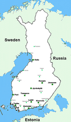
Map of Finland. It has 10 biggest city areas and 15 smaller towns. Created by me.
| I, the copyright holder of this work, release this work into the public domain. This applies worldwide. In some countries this may not be legally possible; if so: I grant anyone the right to use this work for any purpose, without any conditions, unless such conditions are required by law. |
| Annotations | This image is annotated: View the annotations at Commons |
File history
Click on a date/time to view the file as it appeared at that time.
| Date/Time | Thumbnail | Dimensions | User | Comment | |
|---|---|---|---|---|---|
| current | 21:54, 16 June 2005 | | 832 × 1,440 (929 KB) | Vkem~commonswiki |
File usage
No pages on the English Wikipedia use this file (pages on other projects are not listed).
Global file usage
The following other wikis use this file:
- Usage on id.wikipedia.org
- Usage on pl.wikipedia.org
- Usage on su.wikipedia.org
- Usage on tr.wikipedia.org