Size of this preview: 759 × 600 pixels. Other resolutions: 304 × 240 pixels | 608 × 480 pixels | 972 × 768 pixels | 1,280 × 1,011 pixels | 2,560 × 2,022 pixels | 3,980 × 3,144 pixels.
Original file (3,980 × 3,144 pixels, file size: 2.62 MB, MIME type: image/png)
| This is a file from the Wikimedia Commons. Information from its description page there is shown below. Commons is a freely licensed media file repository. You can help. |
| Description |
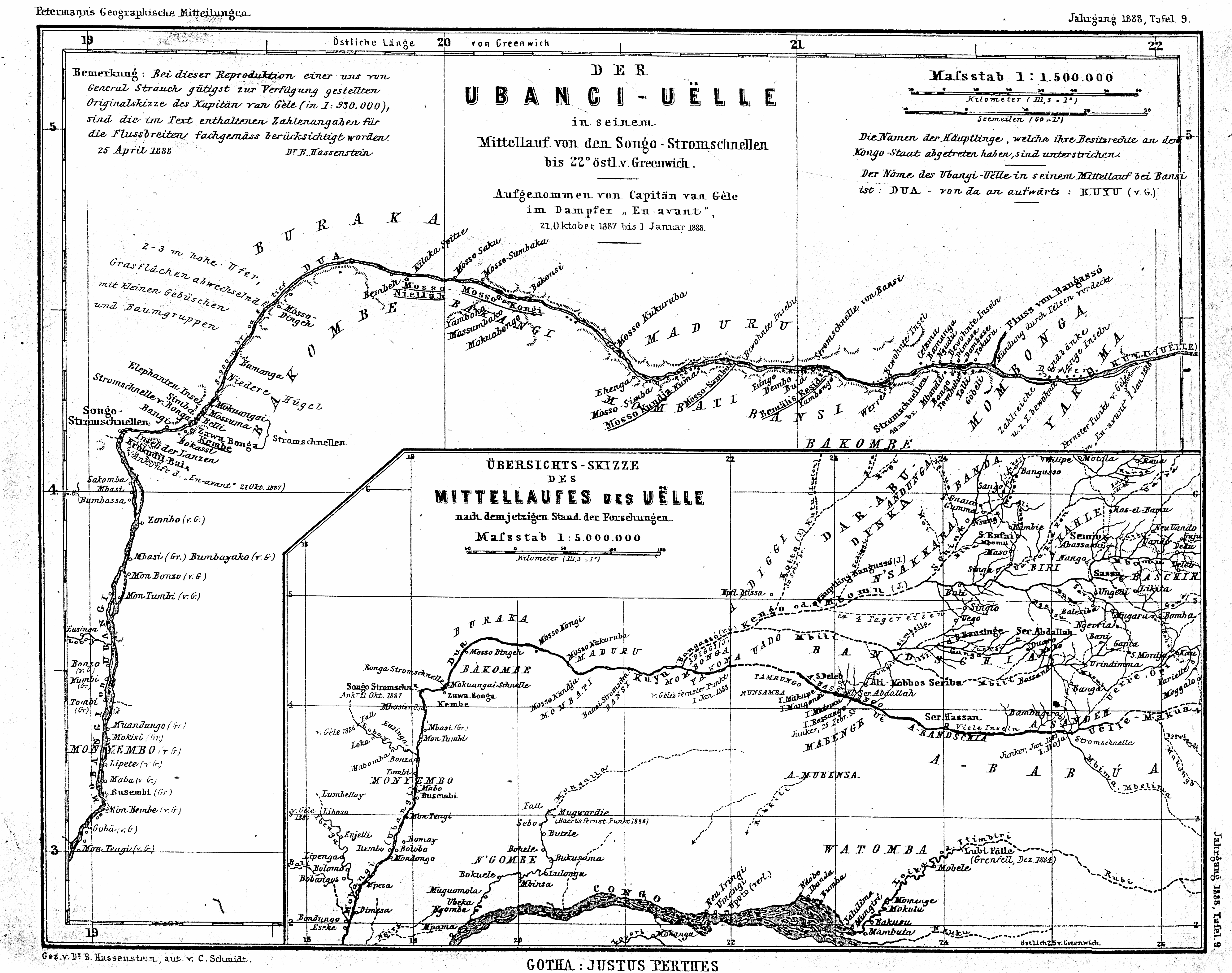
English: The Ubangi-Uëlle river in his middle reaches from the cataracts of Songo to 22° longitude eastwards from Greenwich - recorded by Captain van Gèle from the steamboat "En-avant" in the time between 21st of October 1887 and 1st of January 1888 + Survey sketch of the middle reaches of the Uëlle-river (according to the then state of the researches)
Deutsch: Original caption: " Der Ubangi-Uëlle in seinem Mittellauf von den Songo-Stromschnellen bis 22° östlich von Greenwich - Aufgenommen von Capitän van Gèle im Dampfer "En-avant", 21. Oktober 1887 bis 1. Januar 1888 + Übersichts-Skizze des Mittellaufs des Uëlle nach dem jetzigen Stand der Forschungen " |
||||
| Date | |||||
| Source | Dr. A. Petermanns Mitteilungen aus Justus Perthes Geographischer Anstalt (Gotha), vol.34, 1888 | ||||
| Author |
van Gèle (recorded templates), Carl Schmidt (drawing and autography), B. Hassenstein (drawing and edit), Justus Perthes Geographische Anstalt zu Gotha (publishing company) |
||||
| Permission (Reusing this file) |
|
||||
The middle reaches of the pictured river forms a part of the contemporary border between the Central African Republic and the Democratic Republic of Congo (Congo-Kinshasa).
English: Notice on the map top right:
"The names of the native tribes whose chiefs have ceded their tenures to the State of Congo are underlined. - The name of the Ubangi-Uëlle in his middle reaches at Bansi is "Dua" - and from there upwards: "Kuyu". (van Gèle)"
"The names of the native tribes whose chiefs have ceded their tenures to the State of Congo are underlined. - The name of the Ubangi-Uëlle in his middle reaches at Bansi is "Dua" - and from there upwards: "Kuyu". (van Gèle)"
File history
Click on a date/time to view the file as it appeared at that time.
| Date/Time | Thumbnail | Dimensions | User | Comment | |
|---|---|---|---|---|---|
| current | 20:32, 29 June 2016 | | 3,980 × 3,144 (2.62 MB) | Katharinaiv | {{Information |Description ={{en|1=The Ubangi-Uëlle river in his middle reaches from the cataracts of Songo to 22° longitude eastwards from Greenwich - recorded by Captain van Gèle from the steamboat "En-avant" in the time between 21st of October... |
File usage
No pages on the English Wikipedia use this file (pages on other projects are not listed).
Global file usage
The following other wikis use this file:
- Usage on an.wikipedia.org