
Size of this PNG preview of this SVG file: 800 × 319 pixels. Other resolutions: 320 × 128 pixels | 640 × 255 pixels | 1,024 × 408 pixels | 1,280 × 510 pixels | 2,560 × 1,020 pixels | 911 × 363 pixels.
Original file (SVG file, nominally 911 × 363 pixels, file size: 121 KB)
| This is a file from the Wikimedia Commons. Information from its description page there is shown below. Commons is a freely licensed media file repository. You can help. |
Summary
| Description |
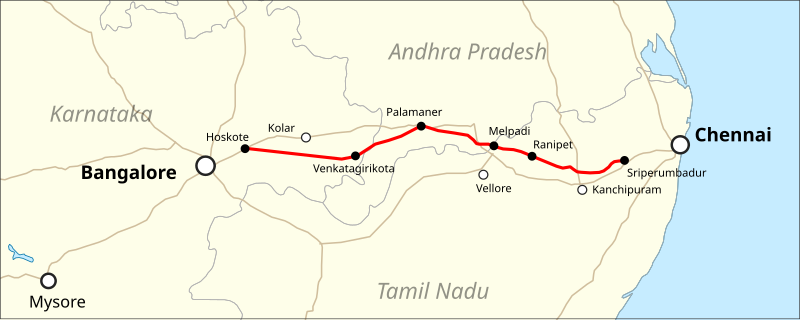
English: Location map of the Bengaluru-Chennai Expressway |
|||
| Date | ||||
| Source |
Map was created using:
|
|||
| Author |
|
|||
| Permission (Reusing this file) |
|
File history
Click on a date/time to view the file as it appeared at that time.
| Date/Time | Thumbnail | Dimensions | User | Comment | |
|---|---|---|---|---|---|
| current | 01:59, 3 January 2020 | 911 × 363 (121 KB) | Pechristener | {{Information |description={{en|Location map of the Bengaluru-Chennai Expressway}} |date=2020-01-02 |source=Map was created using: * [https://www.naturalearthdata.com Natural Earth] for 1:10m Cultural Vectors used for Country Borders & Major Roads |author= * Natural Earth: Tom Patterson, Nathaniel Vaughn Kelso and other contributors * Map rendering: Pechristener using [https://qgis.org QGIS] |permission={{Cc-zero}} |other versions= }} Category:Road maps of India |
File usage
The following pages on the English Wikipedia use this file (pages on other projects are not listed):
Global file usage
The following other wikis use this file:
- Usage on bn.wikipedia.org
- Usage on de.wikipedia.org