
Size of this PNG preview of this SVG file: 744 × 489 pixels. Other resolutions: 320 × 210 pixels | 640 × 421 pixels | 1,024 × 673 pixels | 1,280 × 841 pixels | 2,560 × 1,683 pixels.
Original file (SVG file, nominally 744 × 489 pixels, file size: 734 KB)
| This is a file from the Wikimedia Commons. Information from its description page there is shown below. Commons is a freely licensed media file repository. You can help. |
Summary
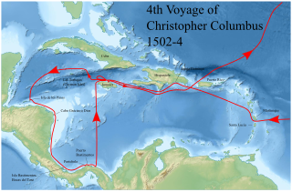
| Description | Map of Caribbean Sea showing the 4th Voyage of Christopher Columbus, 1502-4 |
| Date | |
| Source | Amended from File:Christopher Columbus fourth voyage 1502-1504 map-fr.svg (in French) by User:Sémhur |
| Author | Lobsterthermidor (talk) 20:23, 5 November 2020 (UTC) |
Licensing
This file is licensed under the Creative Commons Attribution-Share Alike 3.0 Unported license.
- You are free:
- to share – to copy, distribute and transmit the work
- to remix – to adapt the work
- Under the following conditions:
- attribution – You must give appropriate credit, provide a link to the license, and indicate if changes were made. You may do so in any reasonable manner, but not in any way that suggests the licensor endorses you or your use.
- share alike – If you remix, transform, or build upon the material, you must distribute your contributions under the same or compatible license as the original.
File history
Click on a date/time to view the file as it appeared at that time.
| Date/Time | Thumbnail | Dimensions | User | Comment | |
|---|---|---|---|---|---|
| current | 20:23, 5 November 2020 | | 744 × 489 (734 KB) | Lobsterthermidor | {{Information |Description=Map of Caribbean Sea showing the 4th Voyage of Christopher Columbus, 1502-4 |Source=Amended from File:Christopher Columbus fourth voyage 1502-1504 map-fr.svg (in French) by User:Sémhur |Date=2020 |Author=~~~~ |Permission= |other_versions= }} Category:Bastimentos, Portobelo Category:Bastimentos Island, Bocas del Toro |
File usage
The following pages on the English Wikipedia use this file (pages on other projects are not listed):