
Size of this preview: 776 × 600 pixels. Other resolutions: 311 × 240 pixels | 621 × 480 pixels | 994 × 768 pixels | 1,280 × 989 pixels | 2,560 × 1,978 pixels | 3,300 × 2,550 pixels.
Original file (3,300 × 2,550 pixels, file size: 1.97 MB, MIME type: image/jpeg)
| This is a file from the Wikimedia Commons. Information from its description page there is shown below. Commons is a freely licensed media file repository. You can help. |
Summary
| Description |
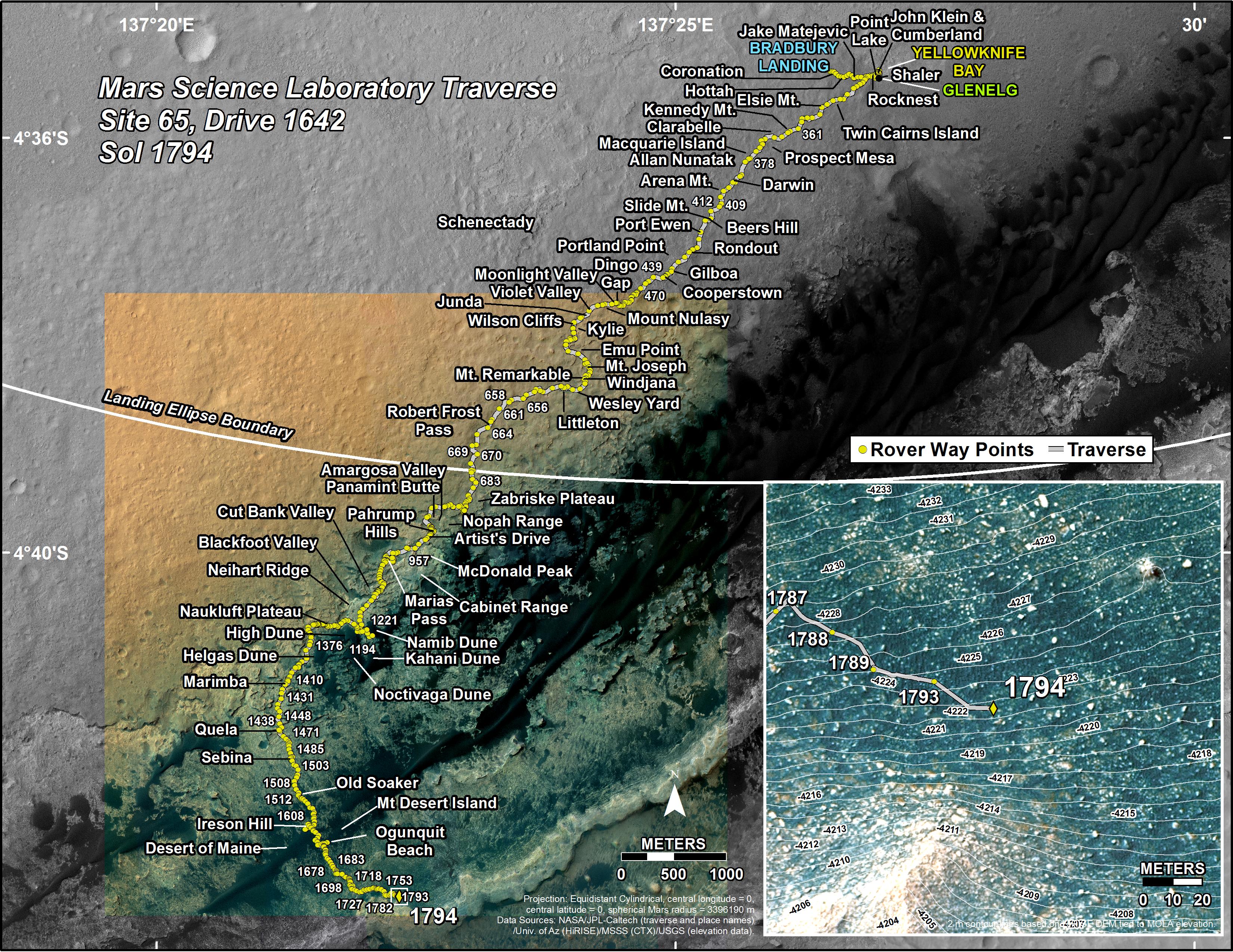
English: This map shows the route driven by NASA's Mars rover Curiosity through the 1794 Martian day, or sol, of the rover's mission on Mars (August 23, 2017).
Numbering of the dots along the line indicate the sol number of each drive. North is up. The scale bar is 1 kilometer (~0.62 mile). From Sol 1793 to Sol 1794, Curiosity had driven a straight line distance of about 72.04 feet (21.96 meters), bringing the rover's total odometry for the mission to 10.69 miles (17.21 kilometers). The base image from the map is from the High Resolution Imaging Science Experiment Camera (HiRISE) in NASA's Mars Reconnaissance Orbiter. |
| Date | |
| Source | https://mars.nasa.gov/multimedia/images/2017/curiositys-traverse-map-through-sol-1794 (image link) |
| Author | NASA/JPL-Caltech/Univ. of Arizona |
Licensing
| This file is in the public domain in the United States because it was solely created by NASA. NASA copyright policy states that "NASA material is not protected by copyright unless noted". (See Template:PD-USGov, NASA copyright policy page or JPL Image Use Policy.) | ||
 |
Warnings:
|
File history
Click on a date/time to view the file as it appeared at that time.
| Date/Time | Thumbnail | Dimensions | User | Comment | |
|---|---|---|---|---|---|
| current | 04:09, 25 August 2017 | | 3,300 × 2,550 (1.97 MB) | Huntster | {{Information |Description={{en|1=This map shows the route driven by NASA's Mars rover Curiosity through the 1794 Martian day, or sol, of the rover's mission on Mars (August 23, 2017). Numbering of the dots along the line indicate the sol number of ea... |
File usage
No pages on the English Wikipedia use this file (pages on other projects are not listed).