
Size of this PNG preview of this SVG file: 390 × 599 pixels. Other resolutions: 156 × 240 pixels | 313 × 480 pixels | 500 × 768 pixels | 667 × 1,024 pixels | 1,334 × 2,048 pixels | 484 × 743 pixels.
Original file (SVG file, nominally 484 × 743 pixels, file size: 485 KB)
| This is a file from the Wikimedia Commons. Information from its description page there is shown below. Commons is a freely licensed media file repository. You can help. |
Summary
| Description |
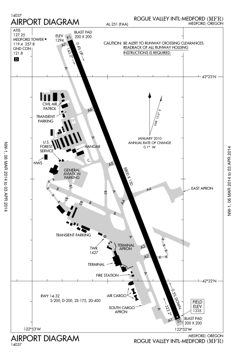
English: FAA airport diagram for MFR (Rogue Valley International-Medford Airport) in Oregon, United States. |
| Date | Unknown date. Effective March 6, 2014 to April 3, 2014. |
| Source | http://aeronav.faa.gov/d-tpp/1403/00251AD.PDF |
| Author | Federal Aviation Administration |
Licensing
This image or file is a work of a Federal Aviation Administration employee, taken or made as part of that person's official duties. As a work of the U.S. federal government, the image is in the public domain in the United States.
|
 |
File history
Click on a date/time to view the file as it appeared at that time.
| Date/Time | Thumbnail | Dimensions | User | Comment | |
|---|---|---|---|---|---|
| current | 23:39, 17 March 2014 | | 484 × 743 (485 KB) | Little Mountain 5 | Update |
| 00:16, 13 August 2013 |  | 484 × 743 (488 KB) | Little Mountain 5 | Update | |
| 00:06, 3 May 2012 |  | 484 × 743 (401 KB) | Little Mountain 5 | This time for real | |
| 23:51, 2 May 2012 |  | 484 × 743 (441 KB) | Little Mountain 5 | Add white background | |
| 15:07, 2 May 2012 |  | 484 × 743 (441 KB) | Little Mountain 5 |
File usage
The following pages on the English Wikipedia use this file (pages on other projects are not listed):
Global file usage
The following other wikis use this file:
- Usage on de.wikipedia.org
- Usage on fa.wikipedia.org
- Usage on vi.wikipedia.org