
Size of this preview: 709 × 600 pixels. Other resolutions: 284 × 240 pixels | 567 × 480 pixels | 908 × 768 pixels | 1,210 × 1,024 pixels | 1,300 × 1,100 pixels.
Original file (1,300 × 1,100 pixels, file size: 857 KB, MIME type: image/jpeg)
| This is a file from the Wikimedia Commons. Information from its description page there is shown below. Commons is a freely licensed media file repository. You can help. |
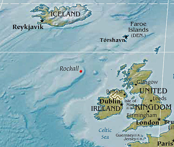
Map displaying the location of Rockall, based on a PD CIA world map. Political designations removed by Bjarki.
This image is in the public domain because it contains materials that originally came from the United States Central Intelligence Agency's World Factbook.
|
 |
File history
Click on a date/time to view the file as it appeared at that time.
| Date/Time | Thumbnail | Dimensions | User | Comment | |
|---|---|---|---|---|---|
| current | 02:02, 8 February 2016 | | 1,300 × 1,100 (857 KB) | Nagualdesign | Removed political designation ("UK"), since the area is disputed. |
| 05:32, 28 December 2015 |  | 1,300 × 1,100 (855 KB) | Nagualdesign | Updated (better resolution) using CIA map. | |
| 13:34, 23 April 2005 |  | 615 × 520 (119 KB) | Bjarki S | Map displaying the location of Rockall, based on a PD CIA world map. Political designations removed by Bjarki. {{PD-USGov-CIA-WF}} |
File usage
The following 3 pages use this file:
Global file usage
The following other wikis use this file:
- Usage on br.wikipedia.org
- Usage on cs.wikipedia.org
- Usage on de.wikipedia.org
- Usage on eu.wikipedia.org
- Usage on fy.wikipedia.org
- Usage on id.wikipedia.org
- Usage on is.wikipedia.org
- Usage on ko.wikipedia.org
- Usage on nl.wikipedia.org
- Usage on nn.wikipedia.org
- Usage on pnb.wikipedia.org
- Usage on sr.wikipedia.org
- Usage on sv.wikipedia.org
- Usage on tr.wikipedia.org
- Usage on vi.wikipedia.org
- Usage on www.wikidata.org