Size of this preview: 773 × 600 pixels. Other resolutions: 310 × 240 pixels | 619 × 480 pixels | 869 × 674 pixels.
Original file (869 × 674 pixels, file size: 1.18 MB, MIME type: image/png)
| This is a file from the Wikimedia Commons. Information from its description page there is shown below. Commons is a freely licensed media file repository. You can help. |
Summary
| Description |
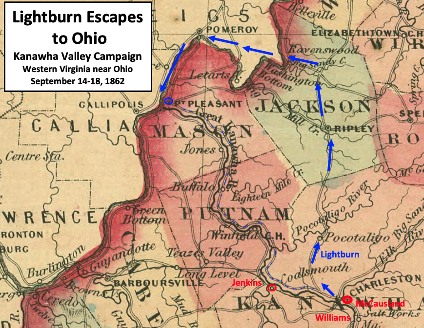
English: This map shows the route of Union Colonel Joseph A. J. Lightburn's retreat from Charleston in the Kanawha Valley Campaign of 1862 during the American Civil War. Lightburn took a route to Ripley and Ravenswood to get to Ohio, and then moved to Point Pleasant. By not using the direct route (dashed blue line), he avoided possible Confederate troops (Jenkins) at Coalsmouth, and the artillery of Confederate Brigadier General John S. Williams who could follow along on the south side of the Kanawha River. Confederate Colonel John McCausland was prevented from the pursuit by the destruction of a bridge across the Elk River at Charleston. |
| Date | |
| Source | This is a crop from Johnson's Virginia, Delaware, Maryland & Virginia map published in 1864. It can be found in the U.S. Library of Congress here. Labels and highlighting have been added by TwoScarsUp based on the book named "The Battle of Charleston and the 1862 Kanawha Valley Campaign" by Terry Lowry. Chapter 8 (beginning on page 239) discusses the retreat from Charleston to the Ohio River. |
| Author | The map is by Alvin Jewett Johnson (1827-1884), and was published in 1864. TwoScarsUp made modifications. |
Western Virginia near Ohio in the USA, now part of West Virginia
Licensing
|
This work is in the public domain in its country of origin and other countries and areas where the copyright term is the author's life plus 70 years or fewer. This work is in the public domain in the United States because it was published (or registered with the U.S. Copyright Office) before January 1, 1929. | |
| This file has been identified as being free of known restrictions under copyright law, including all related and neighboring rights. | |
File history
Click on a date/time to view the file as it appeared at that time.
| Date/Time | Thumbnail | Dimensions | User | Comment | |
|---|---|---|---|---|---|
| current | 19:52, 14 March 2023 | | 869 × 674 (1.18 MB) | TwoScarsUp | Uploaded a work by The map is by Alvin Jewett Johnson (1827-1884), and was published in 1864. TwoScarsUp made modifications. from This is a crop from Johnson's Virginia, Delaware, Maryland & Virginia map published in 1864. It can be found in the U.S. Library of Congress [https://www.loc.gov/item/lva0000026/ here]. Labels and highlighting have been added by TwoScarsUp based on the book named "The Battle of Charleston and the 1862 Kanawha Valley Campaign" by Terry Lowry. Chapter 8 (beginning on... |
File usage
The following pages on the English Wikipedia use this file (pages on other projects are not listed):