
Size of this preview: 800 × 578 pixels. Other resolutions: 320 × 231 pixels | 640 × 462 pixels | 976 × 705 pixels.
Original file (976 × 705 pixels, file size: 166 KB, MIME type: image/jpeg)
| This is a file from the Wikimedia Commons. Information from its description page there is shown below. Commons is a freely licensed media file repository. You can help. |
Summary
| Description |
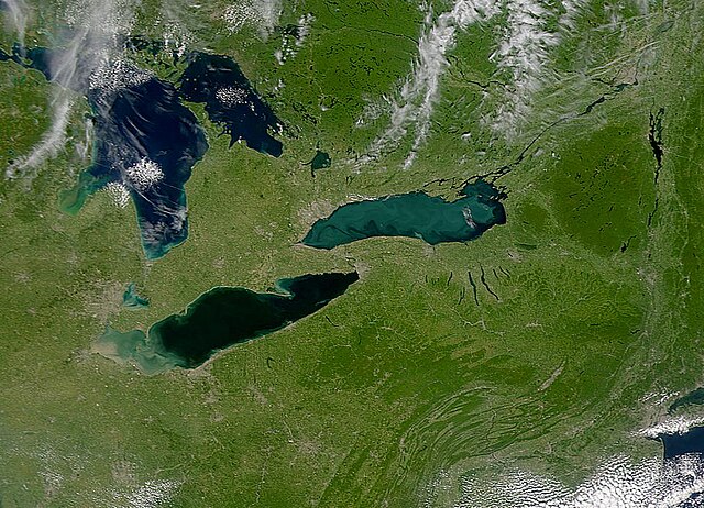
English: Provided by the SeaWiFS Project, NASA/Goddard Space Flight Center, and ORBIMAGE . |
| Date | |
| Source | http://veimages.gsfc.nasa.gov/946/S2000250173937.jpg |
| Author | SeaWiFS Project, NASA/Goddard Space Flight Center, and ORBIMAGE |
Licensing
| This image is from the Sea-viewing Wide Field-of-view Sensor (SeaWiFS) Project and more than 5 years old.
Satellite data captured by the SeaWIFS sensor are released into the public domain 5 years after capture. Data less than five years old can be re-used only for educational or scientific purposes; any commercial use of such images must be coordinated with GeoEye. [1] |
| This work has been released into the public domain by its copyright holder, GeoEye. This applies worldwide. In some countries this may not be legally possible; if so: GeoEye grants anyone the right to use this work for any purpose, without any conditions, unless such conditions are required by law.
|
File history
Click on a date/time to view the file as it appeared at that time.
| Date/Time | Thumbnail | Dimensions | User | Comment | |
|---|---|---|---|---|---|
| current | 04:38, 7 September 2008 | | 976 × 705 (166 KB) | Easchiff | {{Information |Description={{en|1=Provided by the SeaWiFS Project, NASA/Goddard Space Flight Center, and ORBIMAGE .}} |Source=http://veimages.gsfc.nasa.gov/946/S2000250173937.jpg |Author=SeaWiFS Project, NASA/Goddard Space Flight Center, and ORBIMAGE |Da |
File usage
The following pages on the English Wikipedia use this file (pages on other projects are not listed):
Global file usage
The following other wikis use this file:
- Usage on fa.wikipedia.org
- Usage on ka.wikipedia.org