
Size of this preview: 800 × 600 pixels. Other resolutions: 320 × 240 pixels | 640 × 480 pixels | 1,024 × 768 pixels | 1,280 × 960 pixels | 1,600 × 1,200 pixels.
Original file (1,600 × 1,200 pixels, file size: 125 KB, MIME type: image/jpeg)
| This is a file from the Wikimedia Commons. Information from its description page there is shown below. Commons is a freely licensed media file repository. You can help. |
Summary
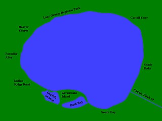
Self created map of Lake George in Anoka County, Mn that documents the various regions around the lake to which residents generally associate themselves. Donald H Burke 04:47, 26 February 2006 (UTC)
- This Wikimedia Commons article is related to Lake George in wikipedia:Anoka County, Minnesota.
Licensing
| I, the copyright holder of this work, release this work into the public domain. This applies worldwide. In some countries this may not be legally possible; if so: I grant anyone the right to use this work for any purpose, without any conditions, unless such conditions are required by law. |
File history
Click on a date/time to view the file as it appeared at that time.
| Date/Time | Thumbnail | Dimensions | User | Comment | |
|---|---|---|---|---|---|
| current | 23:54, 9 March 2006 | | 1,600 × 1,200 (125 KB) | Donald H Burke | |
| 04:47, 26 February 2006 |  | 1,600 × 1,200 (114 KB) | Donald H Burke | Self created map of Lake George in Anoka County, Mn that documents the various regions around the lake to which residents generally associate themselves. ~~~~ Category:Lake views Category:Sunsets [[Category:lakes] |
File usage
The following pages on the English Wikipedia use this file (pages on other projects are not listed):
Global file usage
The following other wikis use this file:
- Usage on www.wikidata.org