
Size of this PNG preview of this SVG file: 532 × 403 pixels. Other resolutions: 317 × 240 pixels | 634 × 480 pixels | 1,014 × 768 pixels | 1,280 × 970 pixels | 2,560 × 1,939 pixels.
Original file (SVG file, nominally 532 × 403 pixels, file size: 254 KB)
| This is a file from the Wikimedia Commons. Information from its description page there is shown below. Commons is a freely licensed media file repository. You can help. |
Summary
| Description |
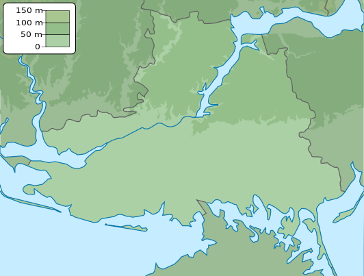
English: Physical map of Kherson province, Ukraine
Русский: Физическая карта Херсонской области, Украина |
| Date | |
| Source | Own work |
| Author | Urutseg |
Licensing
| I, the copyright holder of this work, release this work into the public domain. This applies worldwide. In some countries this may not be legally possible; if so: I grant anyone the right to use this work for any purpose, without any conditions, unless such conditions are required by law. |
File history
Click on a date/time to view the file as it appeared at that time.
| Date/Time | Thumbnail | Dimensions | User | Comment | |
|---|---|---|---|---|---|
| current | 19:13, 17 March 2014 | | 532 × 403 (254 KB) | NordNordWest | more to the south |
| 18:21, 21 December 2010 |  | 532 × 361 (333 KB) | Urutseg | == {{int:filedesc}} == {{Information |Description= {{en|1=Physical map of Kherson province, Ukraine}} {{ru|1=Физическая карта Херсонской области, Украина}} |Source=own work |Date=2010-12-20 |Author=[[:user:Urutseg|Ur |
File usage
The following pages on the English Wikipedia use this file (pages on other projects are not listed):
- Abrykosivka, Kherson Oblast
- Antonivka, Kherson Raion, Kherson Oblast
- Arkhanhelske, Kherson Oblast
- Barvinok, Kherson Oblast
- Beryslav
- Bila Krynytsia, Kherson Oblast
- Bilenke, Kherson Oblast
- Bilohirka, Kherson Oblast
- Bilohrudove
- Blahodatne, Kherson Raion, Kherson Oblast
- Borozenske
- Bruskynske
- Burhunka
- Chonhar
- Chornobaivka
- Chulakivka
- Davydiv Brid
- Dobryanka, Beryslav Raion
- Dzharylhach National Nature Park
- Gammalsvenskby
- Gulf of Tendra
- Havrylivka, Kherson Oblast
- Henichesk
- Henicheska Hirka
- Heroiske, Kherson Oblast
- Hornostaivka, Henichesk Raion, Kherson Oblast
- Inhulivka
- Kakhovka
- Kakhovka Dam
- Kalanchak
- Kherson
- Kherson International Airport
- Kinburn Peninsula
- Kostromka
- Kozachi Laheri, Kherson Raion, Kherson Oblast
- Krynky
- Kyselivka, Kherson Oblast
- Lake Lemuria
- Liubymivka, Henichesk Raion, Kherson Oblast
- Lozove, Kherson Oblast
- Mala Seidemynukha
- Mykhailivka, Beryslav Raion, Kherson Oblast
- Mylove
- Nova Kakhovka
- Novohrednyeve
- Novooleksandrivka, Beryslav Raion, Kherson Oblast
- Novooleksiivka
- Novopetrivka, Vysokopillia settlement hromada, Beryslav Raion, Kherson Oblast
- Novoraisk
- Novovoznesenske
- Oleksandrivka, Kherson Raion, Kherson Oblast
- Oleshky
- Oleshky Sands
- Olhyne, Beryslav Raion
- Osokorivka, Kherson Oblast
- Ostriv Velykyi Potomkin
- Petropavlivka, Beryslav Raion, Kherson Oblast
- Pishchanivka
- Podo-Kalynivka
- Poima
- Posad-Pokrovske
- Pravdyne
- Sablukivka, Kherson Oblast, Ukraine
- Shchaslyvtseve
- Skadovsk
- Sokolohirne
- Soldatske, Kherson Oblast
- Strilkove
- Sukhyi Stavok
- Syvash
- Syvash, Kherson Oblast
- Tavriisk
- Tendra Spit
- Tiahynka
- Trudolyubivka, Beryslav Raion
- Tryfonivka
- Ukrainka, Kherson Oblast
- Vysoke, Kherson Oblast
- Vysokopillia
- Yahorlyk Bay
- Yahorlyk Kut
- Zelenivka, Kherson Oblast
- Zelenyi Hai, Henichesk Raion, Kherson Oblast
- Zelenyi Hai, Kherson Raion, Kherson Oblast
- Zolota Balka
- User:Henri Gopstein/sandbox
- User:Phaisit16207/sandbox 8
- Template:Russo-Ukrainian War detailed relief map (oblasts)
- Module:Location map/data/Ukraine Kherson Oblast
- Module:Location map/data/Ukraine Kherson Oblast/doc
Global file usage
The following other wikis use this file:
- Usage on ar.wikipedia.org
- Usage on avk.wikipedia.org
- Usage on ba.wikipedia.org
- Usage on bcl.wikipedia.org
- Usage on be.wikipedia.org
- Usage on bg.wikipedia.org
- Херсон
- Берислав
- Геническ
- Гола Пристан
- Каховка
- Нова Каховка
- Скадовск
- Таврийск
- Олешки
- Антонивка
- Архангелске
- Аскания Нова
- Била Криниця
- Билозерка
- Бриливка
- Велика Лепетиха
- Велика Олександривка
- Верхний Рогачик
- Високопиля
- Горностаивка
- Днипряни
- Зеленивка
- Иванивка
- Каланчак
- Калинивске
- Карерне
- Козацке
- Комишани
- Лазурне
- Любимивка
- Мирне (Херсонска област)
- Надднипрянске
- Нижни Сиргози
- Нова Маячка
- Нововоронцовка
- Новоолексиивка
- Новотроицке
- Рикове (Украйна)
- Сиваске
- Чаплинка
View more global usage of this file.