Size of this preview: 800 × 545 pixels. Other resolutions: 320 × 218 pixels | 640 × 436 pixels | 1,024 × 697 pixels | 1,420 × 967 pixels.
Original file (1,420 × 967 pixels, file size: 964 KB, MIME type: image/jpeg)
| This is a file from the Wikimedia Commons. Information from its description page there is shown below. Commons is a freely licensed media file repository. You can help. |
Summary
| Description |
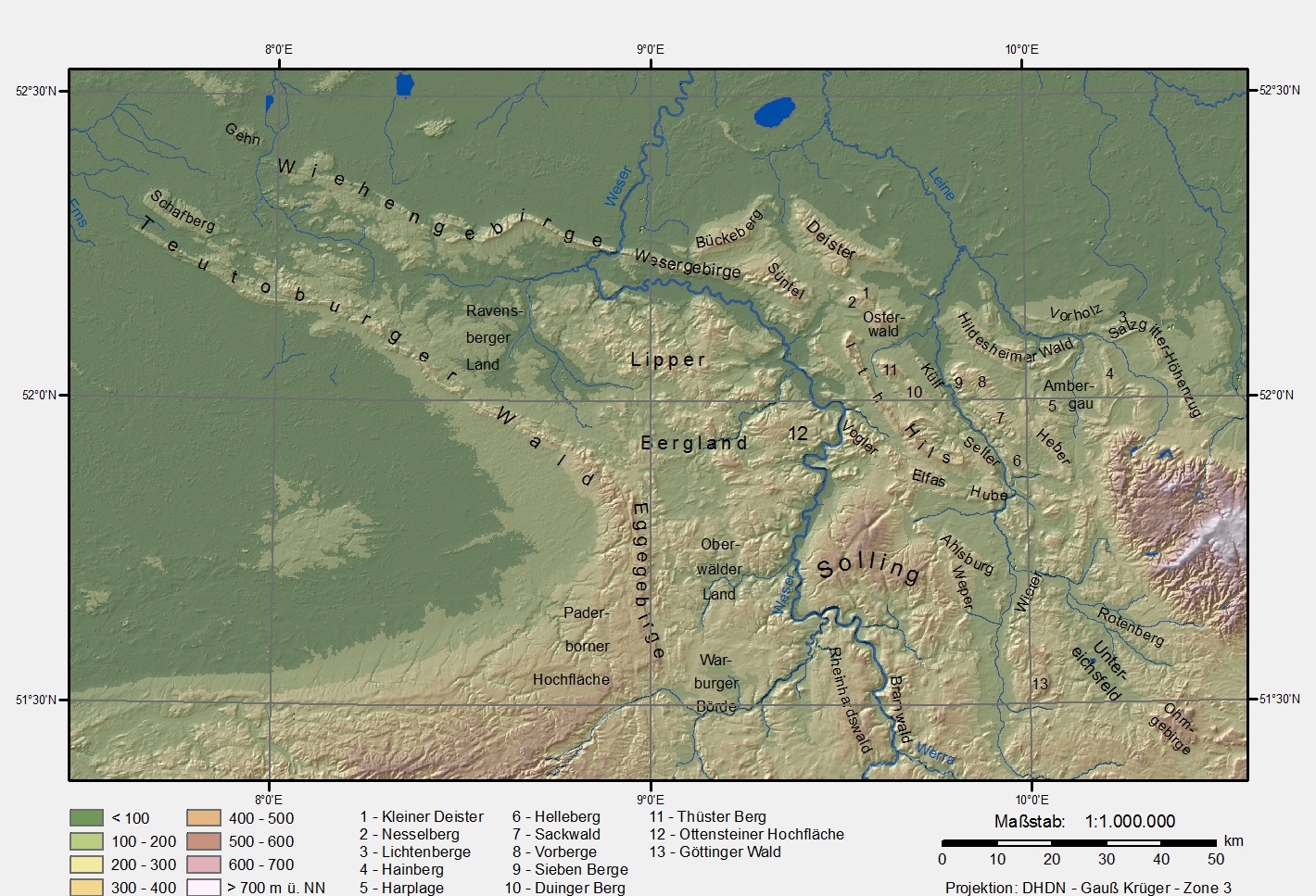
Karte des Niedersächsischen Berglandes (Lower Saxony mountain region). Datengrundlage:
Projektion/Koordinaten:
|
| Date | 6 January 2006 (original upload date) |
| Source | No machine-readable source provided. Own work assumed (based on copyright claims). |
| Author | No machine-readable author provided. Langläufer assumed (based on copyright claims). |
Andere Versionen
Same picture without text and frame (available only in German Wikipedia)
Licensing
| I, the copyright holder of this work, release this work into the public domain. This applies worldwide. In some countries this may not be legally possible; if so: I grant anyone the right to use this work for any purpose, without any conditions, unless such conditions are required by law. |
File history
Click on a date/time to view the file as it appeared at that time.
| Date/Time | Thumbnail | Dimensions | User | Comment | |
|---|---|---|---|---|---|
| current | 13:06, 24 February 2009 | | 1,420 × 967 (964 KB) | Langläufer | rechtschreibfix |
| 11:36, 6 February 2006 |  | 1,422 × 968 (530 KB) | Langläufer | weißer Hintergrund, 150dpi Auflösung | |
| 17:07, 13 January 2006 |  | 948 × 645 (267 KB) | Langläufer | correction of vorberge/sackwald, new legend | |
| 15:38, 12 January 2006 |  | 948 × 652 (292 KB) | Langläufer | scale, projection, legend | |
| 23:38, 6 January 2006 |  | 1,013 × 632 (284 KB) | Langläufer | Karte Niedersächsisches Bergland Basiert auf SRTM-Daten |
File usage
The following pages on the English Wikipedia use this file (pages on other projects are not listed):
Global file usage
The following other wikis use this file:
- Usage on arz.wikipedia.org
- Usage on azb.wikipedia.org
- Usage on bg.wikipedia.org
- Usage on ceb.wikipedia.org
- Usage on da.wikipedia.org
- Usage on de.wikipedia.org
- Solling
- Bramwald
- Reinhardswald
- Paderborner Hochfläche
- Benutzer:Langläufer
- Niedersächsisches Bergland
- Datei:Karte Niedersaechsisches Bergland ohne Namen.jpg
- Datei:Niedersaechsiches-Bergland-topographisch.png
- Benutzer:Ulflulfl/Karten
- Benutzer:Thombansen/Artikel in Überarbeitung 1
- Benutzer:Virtualiter/Baustelle2
- Göttingen-Northeimer Wald
- Diskussion:Wallburgen der Latènezeit in Westfalen-Lippe
- Benutzer:Aeroid/List DE NI-HOL
- Benutzer:Aeroid/List DE NI-NOM
- Benutzer:Aeroid/List DE NI Natural region
- Benutzer Diskussion:TUBS/Archiv/2008
- Usage on de.wikivoyage.org
- Usage on eo.wikipedia.org
- Usage on es.wikipedia.org
- Usage on et.wikipedia.org
- Usage on fr.wikipedia.org
- Usage on fy.wikipedia.org
- Usage on it.wikipedia.org
- Usage on it.wikivoyage.org
- Usage on ja.wikipedia.org
- Usage on lld.wikipedia.org
- Usage on mk.wikipedia.org
- Usage on nds.wikipedia.org
- Usage on nl.wikipedia.org
- Usage on no.wikipedia.org
View more global usage of this file.