Original file (10,195 × 10,195 pixels, file size: 39.94 MB, MIME type: image/jpeg)
| This is a file from the Wikimedia Commons. Information from its description page there is shown below. Commons is a freely licensed media file repository. You can help. |
Summary
| DescriptionInhambane Bay, Mozambique ESA24532875.jpeg |
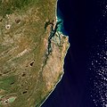
English: Inhambane Bay, in southeast Mozambique, is featured in this true-colour image captured by the Copernicus Sentinel-2 mission. Zoom in to see this image at its full 10 m resolution or click on the circles to learn more about the features in it. Inhambane Bay is a deep inlet into which the small Mutamba River flows. In the north of the bay, where the waters exit into the Mozambique Channel, an arm of the Indian Ocean, different water depths can be identified in tones of green and blue. Two small islands can be seen in Inhambane Bay: Ilha dos Porcos (Pig Island) in the north and Ilha dos Ratos (Rat Island) in the south. On one side of the bay lies the historical city of Inhambane, capital of the Inhambane Province, while the sister city of Maxixe, the economic capital of Inhambane, sits across from it. The province is the second largest grower of cashews, after Nampula, and it also produces coconut and citrus fruits. The region belongs to the Southern Zanzibar–Inhambane coastal forest mosaic, a tropical forest ecoregion of east Africa. The ecoregion stretches around 50 km inwards from the coast and supports a variety of habitats including forest, savanna and swamps. The long coastline of Inhambane supports fishing activities while the stunning beaches of Barra and Tofo, located on the opposite side of the peninsula, are popular seaside destinations. The coastline is also dotted with coral reefs making it a popular region for scuba diving and snorkelling. The waters off the coast are also famed as one of the last remaining populations of dugong in Mozambique. Mozambique’s extensive coastline heightens the country’s vulnerability to tropical cyclones that develop in the Indian Ocean as well as storm surge flooding. More than half of the population lives in low lying coastal areas, putting communities at risk. Inhambane Bay was dangerously close to where Cyclone Idai made landfall in 2019 causing widespread destruction to the country. Satellites orbiting Earth can provide indispensable up-to-date information to observe such events, and, importantly, to map flooded areas for response teams facing these dire situations. This image was captured by the Copernicus Sentinel-2 mission which is based on a constellation of two satellites, both orbiting Earth at an altitude of 786 km but 180° apart. This configuration optimises coverage and global revisit times. This image is also featured on the Earth from Space video programme. |
| Date | 21 October 2022 (upload date) |
| Source | Inhambane Bay, Mozambique |
| Author | European Space Agency |
| Other versions |
|
| Activity InfoField | Observing the Earth |
| Mission InfoField | Sentinel-2 |
| Set InfoField | Earth observation image of the week |
| System InfoField | Copernicus |
Licensing

|
This image contains data from a satellite in the Copernicus Programme, such as Sentinel-1, Sentinel-2 or Sentinel-3. Attribution is required when using this image.
Attribution: Contains modified Copernicus Sentinel data 2022
Attribution
The use of Copernicus Sentinel Data is regulated under EU law (Commission Delegated Regulation (EU) No 1159/2013 and Regulation (EU) No 377/2014). Relevant excerpts:
Free access shall be given to GMES dedicated data [...] made available through GMES dissemination platforms [...].
Access to GMES dedicated data [...] shall be given for the purpose of the following use in so far as it is lawful:
GMES dedicated data [...] may be used worldwide without limitations in time.
GMES dedicated data and GMES service information are provided to users without any express or implied warranty, including as regards quality and suitability for any purpose. |
Attribution
This media was created by the European Space Agency (ESA).
Where expressly so stated, images or videos are covered by the Creative Commons Attribution-ShareAlike 3.0 IGO (CC BY-SA 3.0 IGO) licence, ESA being an Intergovernmental Organisation (IGO), as defined by the CC BY-SA 3.0 IGO licence. The user is allowed under the terms and conditions of the CC BY-SA 3.0 IGO license to Reproduce, Distribute and Publicly Perform the ESA images and videos released under CC BY-SA 3.0 IGO licence and the Adaptations thereof, without further explicit permission being necessary, for as long as the user complies with the conditions and restrictions set forth in the CC BY-SA 3.0 IGO licence, these including that:
See the ESA Creative Commons copyright notice for complete information, and this article for additional details.
|
 | |
This file is licensed under the Creative Commons Attribution-ShareAlike 3.0 IGO license. Attribution: ESA, CC BY-SA IGO 3.0
| ||
Captions
Items portrayed in this file
depicts
image/jpeg
File history
Click on a date/time to view the file as it appeared at that time.
| Date/Time | Thumbnail | Dimensions | User | Comment | |
|---|---|---|---|---|---|
| current | 08:20, 21 October 2022 |  | 10,195 × 10,195 (39.94 MB) | OptimusPrimeBot | #Spacemedia - Upload of https://www.esa.int/var/esa/storage/images/esa_multimedia/images/2022/10/inhambane_bay_mozambique/24532865-2-eng-GB/Inhambane_Bay_Mozambique.jpg via Commons:Spacemedia |
File usage
Metadata
This file contains additional information, probably added from the digital camera or scanner used to create or digitize it.
If the file has been modified from its original state, some details may not fully reflect the modified file.
| Orientation | Normal |
|---|---|
| Horizontal resolution | 72 dpi |
| Vertical resolution | 72 dpi |
| Software used | Adobe Photoshop 23.2 (Windows) |
| File change date and time | 15:35, 14 July 2022 |
| Color space | Uncalibrated |
| Date and time of digitizing | 17:32, 14 July 2022 |
| Date metadata was last modified | 17:35, 14 July 2022 |
| Unique ID of original document | xmp.did:49208847-8869-4b46-828a-4065cf548f63 |


