
Size of this preview: 800 × 492 pixels. Other resolutions: 320 × 197 pixels | 640 × 394 pixels | 1,024 × 630 pixels | 1,280 × 788 pixels | 1,950 × 1,200 pixels.
Original file (1,950 × 1,200 pixels, file size: 634 KB, MIME type: image/png)
| This is a file from the Wikimedia Commons. Information from its description page there is shown below. Commons is a freely licensed media file repository. You can help. |
Summary
| Description |
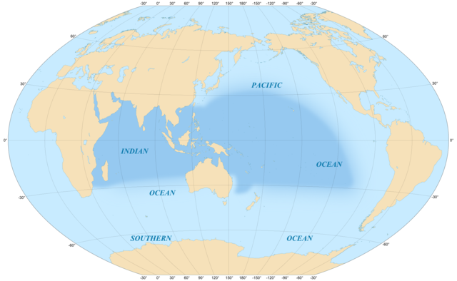
English: Map in English of the area covered by the Indo-Pacific biogeographic region.
Scale : 1:5,000,000 Français : Carte en anglais de la zone couverte par la région biogéographique du bassin Indo-Pacifique.
Winkel Tripel projection, WGS84 datum, central meridian : 150°E.Échelle : 1:5 000 000. |
||
| Date | |||
| Source |
Own work
|
||
| Author | Eric Gaba (Sting - fr:Sting) | ||
| Permission (Reusing this file) |
|
||
| Other versions |
[]
|


Licensing
I, the copyright holder of this work, hereby publish it under the following licenses:

|
Permission is granted to copy, distribute and/or modify this document under the terms of the GNU Free Documentation License, Version 1.2 or any later version published by the Free Software Foundation; with no Invariant Sections, no Front-Cover Texts, and no Back-Cover Texts. A copy of the license is included in the section entitled GNU Free Documentation License. |
This file is licensed under the Creative Commons Attribution-Share Alike 4.0 International, 3.0 Unported, 2.5 Generic, 2.0 Generic and 1.0 Generic license.
- You are free:
- to share – to copy, distribute and transmit the work
- to remix – to adapt the work
- Under the following conditions:
- attribution – You must give appropriate credit, provide a link to the license, and indicate if changes were made. You may do so in any reasonable manner, but not in any way that suggests the licensor endorses you or your use.
- share alike – If you remix, transform, or build upon the material, you must distribute your contributions under the same or compatible license as the original.
You may select the license of your choice.
File history
Click on a date/time to view the file as it appeared at that time.
| Date/Time | Thumbnail | Dimensions | User | Comment | |
|---|---|---|---|---|---|
| current | 12:02, 20 July 2010 | | 1,950 × 1,200 (634 KB) | Sting | With color profile embedded |
| 22:30, 1 September 2008 |  | 1,950 × 1,200 (575 KB) | Sting | New standard colors | |
| 23:22, 25 May 2008 |  | 1,950 × 1,200 (578 KB) | Sting | == Summary == {{Information |Description={{en|Map in English of the area covered by the Indo-Pacific biogeographic region.<br/>Scale : 1:5,000,000}} {{fr|Carte en anglais de la zone couverte par la région biogéographique du [[:fr:Ba |
File usage
The following pages on the English Wikipedia use this file (pages on other projects are not listed):
Global file usage
The following other wikis use this file:
- Usage on ar.wikipedia.org
- Usage on bg.wikipedia.org
- Usage on bn.wikipedia.org
- Usage on cs.wikipedia.org
- Usage on de.wikipedia.org
- Usage on de.wiktionary.org
- Usage on eo.wikipedia.org
- Usage on es.wikipedia.org
- Usage on fa.wikipedia.org
- Usage on fi.wikipedia.org
- Usage on fr.wikipedia.org
- Usage on he.wikipedia.org
- Usage on hi.wikipedia.org
- Usage on id.wikipedia.org
- Usage on it.wikipedia.org
- Usage on ja.wikipedia.org
- Usage on ko.wikipedia.org
- Usage on mrj.wikipedia.org
- Usage on no.wikipedia.org
- Usage on pl.wikipedia.org
- Usage on pt.wikipedia.org
- Indo-Pacífico
- Lambis
- Murex pecten
- Cypraea
- Lambis millepeda
- Lambis lambis
- Conus ammiralis
- Conus aulicus
- Conus bullatus
- Conus geographus
- Conus litteratus
- Conus marmoreus
- Conus nobilis
- Conus striatus
- Conus textile
- Conus tulipa
- Oxymeris maculata
- Lentigo lentiginosus
- Chicoreus ramosus
- Monetaria moneta
- Vasum ceramicum
- Vasum turbinellus
- Cerithium nodulosum
- Turritella terebra
- Terebralia palustris
View more global usage of this file.