Size of this preview: 450 × 600 pixels. Other resolutions: 180 × 240 pixels | 480 × 640 pixels.
Original file (480 × 640 pixels, file size: 84 KB, MIME type: image/jpeg)
| This is a file from the Wikimedia Commons. Information from its description page there is shown below. Commons is a freely licensed media file repository. You can help. |
Summary
| Description |
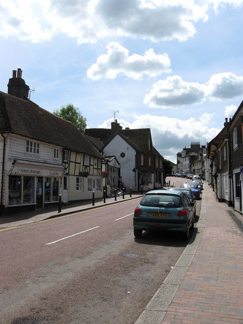
English: High Street Robertsbridge was a medieval development that grew around the Cistercian Priory and the subsequent bridge built by the monks over the nearby River Rother to cater for the Hastings-London road. The village was prosperous between the 14th-16th centuries judging by the number of Wealden Hall Houses built along the village street due to the travelling trade and as the site of both a local market and fair. The former continued into the 18th century being a popular stop for coaches and the street remained the busy A21 until 1992 when a new by-pass was built to the east of the village bringing peace to the main village street. Whilst a small village, Robertsbridge, is one of the larger settlements in one of the less populous areas of the Weald and has therefore retained a number of services with a number of shops, a bank, vets, three pubs and a couple of restaurants. |
| Date | |
| Source | From geograph.org.uk |
| Author | Simon Carey |
| Attribution (required by the license) | Simon Carey / High Street / |
| Camera location | | View this and other nearby images on: OpenStreetMap |
|---|
_heading:180.00&language=en)
| Object location | | View this and other nearby images on: OpenStreetMap |
|---|
_heading:180.00&language=en)
Licensing

|
This image was taken from the Geograph project collection. See this photograph's page on the Geograph website for the photographer's contact details. The copyright on this image is owned by Simon Carey and is licensed for reuse under the Creative Commons Attribution-ShareAlike 2.0 license.
|
This file is licensed under the Creative Commons Attribution-Share Alike 2.0 Generic license.
Attribution: Simon Carey
- You are free:
- to share – to copy, distribute and transmit the work
- to remix – to adapt the work
- Under the following conditions:
- attribution – You must give appropriate credit, provide a link to the license, and indicate if changes were made. You may do so in any reasonable manner, but not in any way that suggests the licensor endorses you or your use.
- share alike – If you remix, transform, or build upon the material, you must distribute your contributions under the same or compatible license as the original.
File history
Click on a date/time to view the file as it appeared at that time.
| Date/Time | Thumbnail | Dimensions | User | Comment | |
|---|---|---|---|---|---|
| current | 06:17, 27 February 2011 | | 480 × 640 (84 KB) | GeographBot | == {{int:filedesc}} == {{Information |description={{en|1=High Street Robertsbridge was a medieval development that grew around the Cistercian Priory and the subsequent bridge built by the monks over the nearby River Rother to cater for the Hastings-London |
File usage
The following pages on the English Wikipedia use this file (pages on other projects are not listed):
Global file usage
The following other wikis use this file:
- Usage on azb.wikipedia.org
- Usage on fa.wikipedia.org