
Size of this preview: 800 × 594 pixels. Other resolutions: 320 × 238 pixels | 640 × 475 pixels | 1,024 × 760 pixels.
Original file (1,024 × 760 pixels, file size: 52 KB, MIME type: image/png)
| This is a file from the Wikimedia Commons. Information from its description page there is shown below. Commons is a freely licensed media file repository. You can help. |
Summary
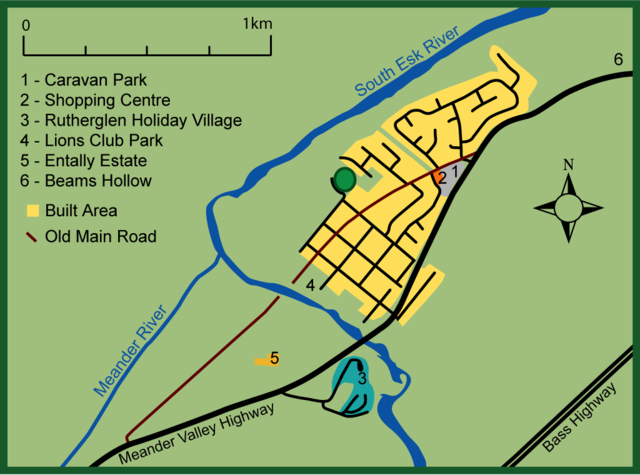
| Description | Map of Hadspen, Tasmania. Based loosly on an aerial map (from page 6 of the October 2011 HADSPEN OUTLINE DEVELOPMENT PLAN - http://www.meander.tas.gov.au/webdata/resources/files/FINAL_Hadspen_ODP_30_9_11.pdf), local street directory and some creative licence in terms of the exact boundary of the built area and river's path. |
| Date | |
| Source | Own work |
| Author | Peripitus |
Licensing
I, the copyright holder of this work, hereby publish it under the following licenses:

|
Permission is granted to copy, distribute and/or modify this document under the terms of the GNU Free Documentation License, Version 1.2 or any later version published by the Free Software Foundation; with no Invariant Sections, no Front-Cover Texts, and no Back-Cover Texts. A copy of the license is included in the section entitled GNU Free Documentation License. |
This file is licensed under the Creative Commons Attribution 3.0 Unported license.
- You are free:
- to share – to copy, distribute and transmit the work
- to remix – to adapt the work
- Under the following conditions:
- attribution – You must give appropriate credit, provide a link to the license, and indicate if changes were made. You may do so in any reasonable manner, but not in any way that suggests the licensor endorses you or your use.
You may select the license of your choice.
File history
Click on a date/time to view the file as it appeared at that time.
| Date/Time | Thumbnail | Dimensions | User | Comment | |
|---|---|---|---|---|---|
| current | 13:09, 29 June 2012 | | 1,024 × 760 (52 KB) | Peripitus | perhaps larger fonts ? |
| 12:49, 29 June 2012 |  | 1,024 × 760 (47 KB) | Peripitus | {{Information |Description=Map of Hadspen, Tasmania. Based on an aerial map, local street directory and some creative licence in terms of the exact boundary of the built area. |Source={{self}} |Date=29 June 2012 |Author=Peripitus }}... |
File usage
The following pages on the English Wikipedia use this file (pages on other projects are not listed):
Global file usage
The following other wikis use this file:
- Usage on ru.wikipedia.org
- Usage on www.wikidata.org