
Size of this PNG preview of this SVG file: 800 × 599 pixels. Other resolutions: 320 × 240 pixels | 640 × 479 pixels | 1,024 × 767 pixels | 1,280 × 958 pixels | 2,560 × 1,916 pixels | 3,389 × 2,537 pixels.
Original file (SVG file, nominally 3,389 × 2,537 pixels, file size: 1.9 MB)
| This is a file from the Wikimedia Commons. Information from its description page there is shown below. Commons is a freely licensed media file repository. You can help. |
Summary
| Description |
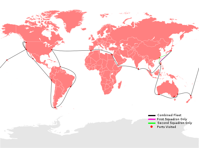
English: A map of the route taken by the Great White Fleet from December 1907 to February 1909. Created using this blank map by João Felipe C.S as a template. Note that the countries are drawn with their modern boundaries (not as they were in 1907-1909) and are there for reference.
This W3C-unspecified vector image was created with Inkscape . |
| Date | |
| Source | Own work |
| Author | TastyCakes |
.svg)
Licensing
I, the copyright holder of this work, hereby publish it under the following license:
This file is licensed under the Creative Commons Attribution 3.0 Unported license.
- You are free:
- to share – to copy, distribute and transmit the work
- to remix – to adapt the work
- Under the following conditions:
- attribution – You must give appropriate credit, provide a link to the license, and indicate if changes were made. You may do so in any reasonable manner, but not in any way that suggests the licensor endorses you or your use.
File history
Click on a date/time to view the file as it appeared at that time.
| Date/Time | Thumbnail | Dimensions | User | Comment | |
|---|---|---|---|---|---|
| current | 18:16, 23 February 2009 | | 3,389 × 2,537 (1.9 MB) | TastyCakes | {{Information |Description={{en|1=A map of the route taken by the Great White Fleet from December 1907 to February 1909. Created using this blank map by João Felipe C.S as a t |
.svg)
File usage
The following pages on the English Wikipedia use this file (pages on other projects are not listed):
Global file usage
The following other wikis use this file:
- Usage on de.wikipedia.org
- Usage on es.wikipedia.org
- Usage on fr.wikipedia.org
- Usage on he.wikipedia.org
- Usage on id.wikipedia.org
- Usage on it.wikipedia.org
- Usage on ja.wikipedia.org
- Usage on ko.wikipedia.org
- Usage on nl.wikipedia.org
- Usage on pt.wikipedia.org
- Usage on ru.wikipedia.org
- Usage on tr.wikipedia.org
- Usage on uk.wikipedia.org
- Великий Білий флот
- USS Maine (BB-10)
- USS Illinois (BB-7)
- USS Kansas (BB-21)
- USS Minnesota (BB-22)
- USS Missouri (BB-11)
- USS Ohio (BB-12)
- USS Virginia (BB-13)
- USS Connecticut (BB-18)
- USS Vermont (BB-20)
- USS Georgia (BB-15)
- USS Rhode Island (BB-17)
- USS Louisiana (BB-19)
- USS Kentucky (BB-6)
- USS Truxtun (DD-14)
- USS Glacier (AF-4)
- USS Hopkins (DD-6)
- USS Hull (DD-7)
- USS Lawrence (DD-8)
- USS Stewart (DD-13)
- USS Whipple (DD-15)
- USS Relief (1896)
- USS Yankton (1893)
- USS Arethusa (AO-7)
- USS Culgoa (AF-3)
- USS Panther (1889)
- Usage on vi.wikipedia.org
- Usage on zh.wikipedia.org