
Size of this preview: 600 × 600 pixels. Other resolutions: 240 × 240 pixels | 480 × 480 pixels | 768 × 768 pixels | 1,024 × 1,024 pixels | 2,400 × 2,400 pixels.
Original file (2,400 × 2,400 pixels, file size: 2.77 MB, MIME type: image/jpeg)
| This is a file from the Wikimedia Commons. Information from its description page there is shown below. Commons is a freely licensed media file repository. You can help. |
Summary
| Description |
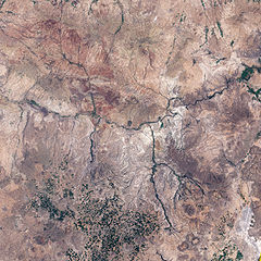
English: This is an image of Göreme National Park and its surroundings in Cappadocia, Turkey. A black outline delineates park boundaries.
|
| Date | |
| Source | NASA Earth Observatory |
| Author | Jesse Allen |
Image created using Landsat data provided by the United States Geological Survey. Instrument: Landsat 7 - ETM+
Licensing
| This file is in the public domain in the United States because it was solely created by NASA. NASA copyright policy states that "NASA material is not protected by copyright unless noted". (See Template:PD-USGov, NASA copyright policy page or JPL Image Use Policy.) | ||
 |
Warnings:
|
File history
Click on a date/time to view the file as it appeared at that time.
| Date/Time | Thumbnail | Dimensions | User | Comment | |
|---|---|---|---|---|---|
| current | 09:53, 7 June 2009 | | 2,400 × 2,400 (2.77 MB) | Originalwana | {{Information |Description={{en|1=This is an image of Göreme National Park and its surroundings in Cappadocia. A black outline delineates park boundaries. Although the satellite’s perspective doesn't quite match the spectacular scenery from the ground, |
File usage
The following pages on the English Wikipedia use this file (pages on other projects are not listed):
Global file usage
The following other wikis use this file: