
Size of this preview: 458 × 599 pixels. Other resolutions: 183 × 240 pixels | 367 × 480 pixels | 980 × 1,282 pixels.
Original file (980 × 1,282 pixels, file size: 240 KB, MIME type: image/jpeg)
| This is a file from the Wikimedia Commons. Information from its description page there is shown below. Commons is a freely licensed media file repository. You can help. |

|
This map image could be re-created using vector graphics as an SVG file. This has several advantages; see Commons:Media for cleanup for more information. If an SVG form of this image is available, please upload it and afterwards replace this template with
{{vector version available|new image name}}.
It is recommended to name the SVG file “GolanHights.svg”—then the template Vector version available (or Vva) does not need the new image name parameter. |


Summary
| Description |
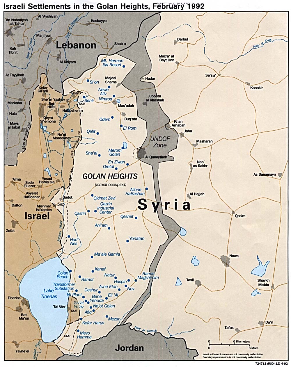
Deutsch: Die Golanhöhen damals und heute, nach den Eroberungen von 1967 und 1973. |
| Date | 22 January 2006 (original upload date) |
| Source | Als Basis diente folgende Karte, die sich laut en.wiki unter public domain befindet.; |
| Author | Hoheit at German Wikipedia |
Licensing
Hoheit at the German-language Wikipedia, the copyright holder of this work, hereby publishes it under the following license:

|
Permission is granted to copy, distribute and/or modify this document under the terms of the GNU Free Documentation License, Version 1.2 or any later version published by the Free Software Foundation; with no Invariant Sections, no Front-Cover Texts, and no Back-Cover Texts. A copy of the license is included in the section entitled GNU Free Documentation License. |
| This file is licensed under the Creative Commons Attribution-Share Alike 3.0 Unported license. | ||
| Attribution: Hoheit | ||
| ||
| This licensing tag was added to this file as part of the GFDL licensing update. |
Original upload log
Transferred from de.wikipedia to Commons by Akkakk.
The original description page was here. All following user names refer to de.wikipedia.
- 2006-01-22 16:41 Hoheit 980×1282× (246008 bytes) Die Golanhöhen damals und heute, nach den Eroberungen von 1967 und 1973. Als Basis diente folgende [http://www.lib.utexas.edu/maps/middle_east_and_asia/golan_92.jpg Karte], die sich laut [http://en.wikipedia.org/wiki/Image:Golan_92.jpg en.wiki] unter pu
File history
Click on a date/time to view the file as it appeared at that time.
| Date/Time | Thumbnail | Dimensions | User | Comment | |
|---|---|---|---|---|---|
| current | 13:57, 31 July 2011 | | 980 × 1,282 (240 KB) | Akkakk | {{Information |Description={{de|Die Golanhöhen damals und heute, nach den Eroberungen von 1967 und 1973.}} |Source=Als Basis diente folgende [http://www.lib.utexas.edu/maps/middle_east_and_asia/golan_92.jpg Karte], die sich laut [http://en.wikipedia.org/ |
File usage
The following pages on the English Wikipedia use this file (pages on other projects are not listed):
Global file usage
The following other wikis use this file:
- Usage on de.wikipedia.org