
Size of this preview: 800 × 583 pixels. Other resolutions: 320 × 233 pixels | 640 × 467 pixels | 1,045 × 762 pixels.
Original file (1,045 × 762 pixels, file size: 128 KB, MIME type: image/jpeg)
| This is a file from the Wikimedia Commons. Information from its description page there is shown below. Commons is a freely licensed media file repository. You can help. |
Summary
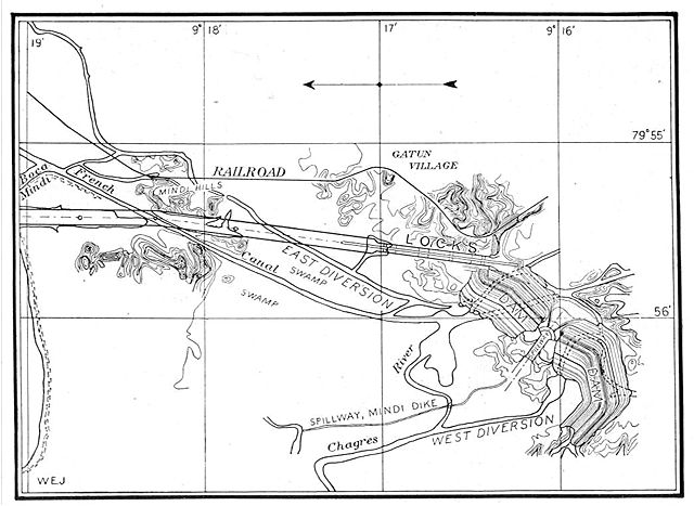
This map from the construction of the Panama Canal illustrates the north end of the canal, showing the area around the Gatun locks and Gatun Dam. The proposed lock and dam structures are shown superposed over the waterways existing at the end of the French attempt to build a sea-level canal there. North is to the left.
From An address to the National Geographic Society by George Washington Goethals, February 10, 1911.
Licensing
This media file is in the public domain in the United States. This applies to U.S. works where the copyright has expired, often because its first publication occurred prior to January 1, 1929, and if not then due to lack of notice or renewal. See this page for further explanation.
|
 | |
 |
This image might not be in the public domain outside of the United States; this especially applies in the countries and areas that do not apply the rule of the shorter term for US works, such as Canada, Mainland China (not Hong Kong or Macao), Germany, Mexico, and Switzerland. The creator and year of publication are essential information and must be provided. See Wikipedia:Public domain and Wikipedia:Copyrights for more details.
|
File history
Click on a date/time to view the file as it appeared at that time.
| Date/Time | Thumbnail | Dimensions | User | Comment | |
|---|---|---|---|---|---|
| current | 17:42, 29 October 2005 | | 1,045 × 762 (128 KB) | Johantheghost | This map from the construction of the Panama Canal illustrates the north end of the canal, showing the area around the Gatun locks and Gatun Dam. The proposed lock and dam structures are shown superposed |
File usage
The following pages on the English Wikipedia use this file (pages on other projects are not listed):
Global file usage
The following other wikis use this file:
- Usage on ca.wikipedia.org
- Usage on cs.wikipedia.org
- Usage on de.wikipedia.org
- Usage on es.wikipedia.org
- Usage on fr.wikipedia.org