
Size of this preview: 800 × 399 pixels. Other resolutions: 320 × 160 pixels | 640 × 319 pixels | 1,024 × 511 pixels | 1,280 × 639 pixels | 2,560 × 1,278 pixels | 8,058 × 4,022 pixels.
Original file (8,058 × 4,022 pixels, file size: 1.47 MB, MIME type: image/png)
| This is a file from the Wikimedia Commons. Information from its description page there is shown below. Commons is a freely licensed media file repository. You can help. |
Summary
| Description |
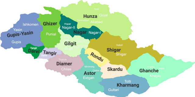
English: Gilgit-Baltistan map with tehsils labelled |
| Date | (updated 2019) |
| Source | Own work |
| Author | Kazmi |
Licensing
I, the copyright holder of this work, hereby publish it under the following license:
This file is licensed under the Creative Commons Attribution-Share Alike 4.0 International license.
- You are free:
- to share – to copy, distribute and transmit the work
- to remix – to adapt the work
- Under the following conditions:
- attribution – You must give appropriate credit, provide a link to the license, and indicate if changes were made. You may do so in any reasonable manner, but not in any way that suggests the licensor endorses you or your use.
- share alike – If you remix, transform, or build upon the material, you must distribute your contributions under the same or compatible license as the original.
File history
Click on a date/time to view the file as it appeared at that time.
| Date/Time | Thumbnail | Dimensions | User | Comment | |
|---|---|---|---|---|---|
| current | 10:14, 19 June 2019 | | 8,058 × 4,022 (1.47 MB) | Kazmi | Added missing details - district Tangir and Darel - Added names of main localities |
| 01:19, 19 June 2019 |  | 8,058 × 4,022 (1.36 MB) | Kazmi | Added names and redefined the boundaries of newly established districts | |
| 01:50, 28 June 2017 |  | 1,952 × 997 (80 KB) | Kazmi | User created page with UploadWizard |
File usage
More than 100 pages use this file. The following list shows the first 100 pages that use this file only. A full list is available.
- Abruzzi Glacier
- Ahmedabad (Hunza)
- Angel Sar
- Askole
- Astore District
- Astore River
- Astore Valley
- Astore Wildlife Sanctuary
- Attabad
- Bagrot Valley
- Baintha Brakk
- Baltistan Wildlife Sanctuary
- Baltoro Kangri
- Batbaykor
- Batura Glacier
- Batura Sar
- Biarchedi
- Biarchedi Glacier
- Bichhar Pass
- Burzil Pass
- Chaprot Pass
- Chillinji Pass
- Chilum
- Chogolisa
- Choungrah
- Dashkin
- Dassu, Gilgit–Baltistan
- Diamer District
- Diran
- Distaghil Sar
- Districts of Pakistan
- Douan
- Eidgah, Astore
- Gahkuch
- Gasherbrum III
- Gasherbrum IV
- Gasherbrum V
- Geography of Gilgit-Baltistan
- Ghanche District
- Gilgit-Baltistan
- Gilgit Agency
- Gilgit District
- Gilgit Tehsil
- Gilgit Valley
- Gudai
- Haramosh Peak
- Hispar Glacier
- Hispar Muztagh
- Hispar Pass
- Hispar River
- Irshad Pass
- K6 (mountain)
- Kanjut Sar
- Karakoram Province
- Korphe
- Koyo Zom
- Kunyang Chhish
- Ladyfinger Peak
- Laila Peak (Haramosh Valley)
- Laila Peak (Rupal Valley)
- Lupghar Pir Pass
- Malubiting
- Masherbrum
- Miar Peak
- Mingli Sar
- Murtazaabad
- Naltar Peak
- Nasirabad (Hunza)
- Nilt
- Panmah Muztagh
- Parishing
- Passu Sar
- Phuparash Peak
- Pumari Chhish
- Punial
- Rakaposhi-Haramosh Mountains
- Rupal Peak
- Rupal Valley
- Rush Peak
- Shaigiri
- Shani Peak
- Sherpi Kangri
- Shigar
- Shigar River
- Shigar Valley
- Shispare
- Sikandarabad, Gilgit–Baltistan
- Skardu District
- Skardu Valley
- Snow Dome, Concordia
- Snow Lake (Pakistan)
- Spantik-Sosbun Mountains
- Sust
- Taghafari
- Toltar
- Trivor
- Uli Biaho
- Vigne Glacier
- Yukshin Gardan Sar
- Zagaran Pass
View more links to this file.
Global file usage
The following other wikis use this file:
- Usage on bn.wikipedia.org
- Usage on it.wikipedia.org
- Usage on ja.wikipedia.org
- Usage on pnb.wikipedia.org
- Usage on sd.wikipedia.org
- Usage on ta.wikipedia.org
- Usage on uk.wikipedia.org
- Usage on ur.wikipedia.org
View more global usage of this file.