Size of this preview: 692 × 599 pixels. Other resolutions: 277 × 240 pixels | 554 × 480 pixels | 887 × 768 pixels | 1,024 × 887 pixels.
Original file (1,024 × 887 pixels, file size: 228 KB, MIME type: image/png)
| This is a file from the Wikimedia Commons. Information from its description page there is shown below. Commons is a freely licensed media file repository. You can help. |

Summary
| Description |
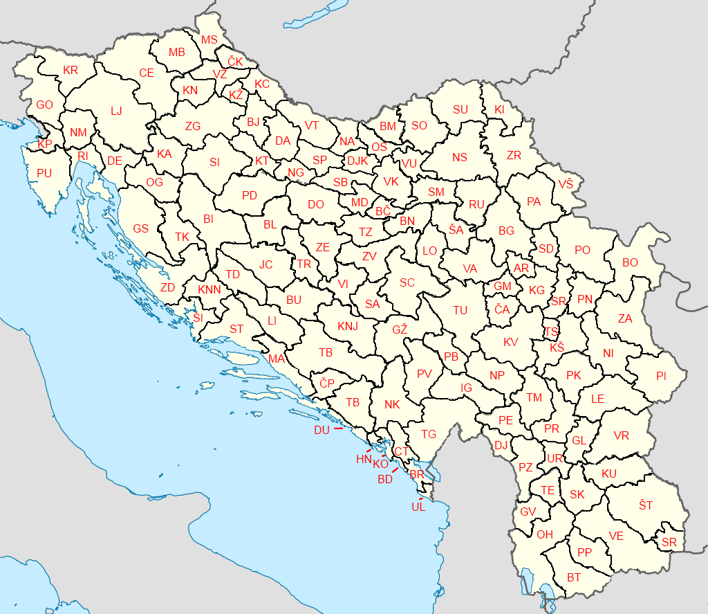
English: I made a geographic map of the Yugoslav license plates, where you can see where you could register a car in the former Yugoslavia, and today the map looks a bit like this.
Srpskohrvatski / српскохрватски: Napravio sam geografsku kartu registarskih tablica Jugoslavije na kojoj možete videti gde možete da registrujete automobil u bivšoj Jugoslaviji, a danas je karta pomalo takva. |
| Date | |
| Source | Own work |
| Author | YugoslavPower |
Licensing
I, the copyright holder of this work, hereby publish it under the following license:
This file is licensed under the Creative Commons Attribution-Share Alike 4.0 International license.
- You are free:
- to share – to copy, distribute and transmit the work
- to remix – to adapt the work
- Under the following conditions:
- attribution – You must give appropriate credit, provide a link to the license, and indicate if changes were made. You may do so in any reasonable manner, but not in any way that suggests the licensor endorses you or your use.
- share alike – If you remix, transform, or build upon the material, you must distribute your contributions under the same or compatible license as the original.
File history
Click on a date/time to view the file as it appeared at that time.
| Date/Time | Thumbnail | Dimensions | User | Comment | |
|---|---|---|---|---|---|
| current | 12:21, 7 March 2023 | | 1,024 × 887 (228 KB) | YugoslavPower | Reverted to version as of 19:30, 1 January 2023 (UTC) |
| 12:45, 17 February 2023 |  | 1,024 × 887 (175 KB) | Glide08 | Reverted to version as of 20:16, 11 December 2022 (UTC) - this map is published under a Creative Commons Attribution-Share Alike 4.0 International license, so there *is* a right to change that map without your permission | |
| 19:30, 1 January 2023 |  | 1,024 × 887 (228 KB) | YugoslavPower | It should be like how I made the map, nobody has the right to change it witouth my permission. ZD and GS code is also mixed | |
| 20:16, 11 December 2022 |  | 1,024 × 887 (175 KB) | Glide08 | Reverted to version as of 15:29, 30 October 2022 (UTC) Stop reverting to the version where the constituent units' borders are unmarked. These were still federal units within the SFRY and were "above" the normal interdistrict boundaries | |
| 00:27, 1 December 2022 |  | 1,024 × 887 (228 KB) | YugoslavPower | Reverted to version as of 11:29, 6 February 2022 (UTC) | |
| 15:29, 30 October 2022 |  | 1,024 × 887 (175 KB) | Glide08 | Reverted to version as of 11:05, 16 October 2020 (UTC) - these borders still existed, as the borders of its constituent republics (note, for example, that the border between Vojvodina and Serbia is also marked due to its status as an autonomous province under the SFRY, even though Vojvodina is not an independent state now) | |
| 11:29, 6 February 2022 |  | 1,024 × 887 (228 KB) | Frank b26 | ZD and GS codes were mixed | |
| 15:30, 4 November 2021 |  | 1,024 × 887 (250 KB) | YugoslavPower | Reverted to version as of 11:44, 17 July 2020 (UTC) Yugoslavia was one country at the time, so it should be witouth borders | |
| 11:05, 16 October 2020 |  | 1,024 × 887 (175 KB) | Glide08 | Reverted to version as of 22:06, 14 May 2020 (UTC) The republic and province broders clarify which district is in which republic/district and should be included | |
| 16:39, 17 July 2020 |  | 1,024 × 887 (250 KB) | YugoslavPower | please |
File usage
The following pages on the English Wikipedia use this file (pages on other projects are not listed):
Global file usage
The following other wikis use this file:
- Usage on pl.wikipedia.org