
Size of this preview: 600 × 600 pixels. Other resolutions: 240 × 240 pixels | 480 × 480 pixels | 768 × 768 pixels | 1,024 × 1,024 pixels | 1,280 × 1,280 pixels.
Original file (1,280 × 1,280 pixels, file size: 1.21 MB, MIME type: image/png)
| This is a file from the Wikimedia Commons. Information from its description page there is shown below. Commons is a freely licensed media file repository. You can help. |
Summary
| Description |
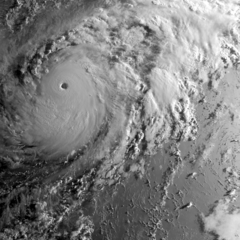
English: Super Typhoon Genevieve during its peak intensity near the International Date Line on August 7, 2014, captured on the MTSAT-2 satellite. |
| Date | |
| Source | https://www.nrlmry.navy.mil/archdat/test/kml/TC/2014/EPAC/07E/visir/20140807.1832.MTSAT2.vis.07E.GENEVIEVE.EPAC.png |
| Author | Naval Research Laboratory |
| Metadata | https://www.nrlmry.navy.mil/archdat/test/kml/TC/2014/EPAC/07E/visir/20140807.1832.MTSAT2.vis.07E.GENEVIEVE.EPAC.png.txt |
| Satellite | MTSAT-2 |
| Camera location | | View this and other nearby images on: OpenStreetMap |
|---|
Licensing
This file is a work of a sailor or employee of the U.S. Navy, taken or made as part of that person's official duties. As a work of the U.S. federal government, it is in the public domain in the United States.
|
 | |
| This file has been identified as being free of known restrictions under copyright law, including all related and neighboring rights. | ||
File history
Click on a date/time to view the file as it appeared at that time.
| Date/Time | Thumbnail | Dimensions | User | Comment | |
|---|---|---|---|---|---|
| current | 06:43, 2 February 2019 | | 1,280 × 1,280 (1.21 MB) | Nino Marakot | User created page with UploadWizard |
File usage
The following pages on the English Wikipedia use this file (pages on other projects are not listed):