Size of this preview: 800 × 300 pixels. Other resolutions: 320 × 120 pixels | 640 × 240 pixels | 1,024 × 384 pixels | 2,266 × 850 pixels.
Original file (2,266 × 850 pixels, file size: 706 KB, MIME type: image/jpeg)
| This is a file from the Wikimedia Commons. Information from its description page there is shown below. Commons is a freely licensed media file repository. You can help. |
Summary
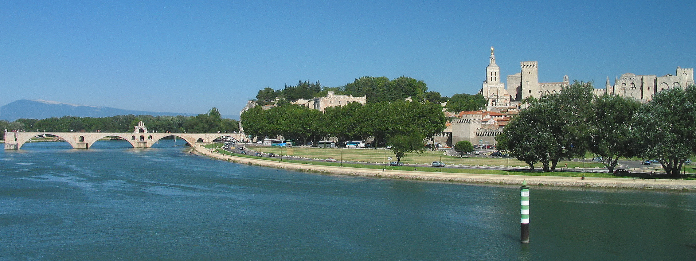
Avignon France Total View
Own Picture 07/2005
Photographer: Rolf Süssbrich
Légende détaillée de la photo : à gauche, sur le bras gauche du Rhône (fr), le pont Saint-Bénezet (fr) avec, en arrière-plan, l'île de la Barthelasse (entre les deux bras du Rhône) puis, beaucoup plus éloigné (environ 35 km vers le nord-est) le mont Ventoux (fr) ; au centre, caché par les arbres, le musée du Petit Palais ; entre les arbres, au premier plan, un pan du Rempart ; au second plan, la cathédrale Notre-Dame-des-Doms puis le palais des Papes (fr).
| Camera location | | View this and other nearby images on: OpenStreetMap |
|---|
Licensing
I, the copyright holder of this work, hereby publish it under the following license:

|
Permission is granted to copy, distribute and/or modify this document under the terms of the GNU Free Documentation License, Version 1.2 or any later version published by the Free Software Foundation; with no Invariant Sections, no Front-Cover Texts, and no Back-Cover Texts. A copy of the license is included in the section entitled GNU Free Documentation License. |
| This file is licensed under the Creative Commons Attribution-Share Alike 3.0 Unported license. | ||
| ||
| This licensing tag was added to this file as part of the GFDL licensing update. |
File history
Click on a date/time to view the file as it appeared at that time.
| Date/Time | Thumbnail | Dimensions | User | Comment | |
|---|---|---|---|---|---|
| current | 17:48, 14 July 2015 | 2,266 × 850 (706 KB) | Rsuessrb | Noise reduced, improved colours | |
| 11:48, 8 August 2012 | 2,280 × 922 (661 KB) | Rsuessrb | Distortion corrected | ||
| 11:42, 8 August 2012 |  | 2,272 × 1,026 (752 KB) | Rsuessrb | Newly processed | |
| 22:00, 22 March 2009 | 2,268 × 804 (380 KB) | Rsuessrb | Newly derived from original: distortion corrected, colour saturation reduced, display optimzed for flat screens. | ||
| 22:42, 20 September 2005 | 2,272 × 716 (280 KB) | Rsuessrb | |||
| 11:09, 20 September 2005 | 2,270 × 783 (214 KB) | Rsuessrb | Pic improved | ||
| 20:43, 16 September 2005 | 2,270 × 783 (190 KB) | Rsuessrb | |||
| 10:58, 14 September 2005 | 2,270 × 783 (176 KB) | Rsuessrb | Avignon France Total View |
File usage
The following pages on the English Wikipedia use this file (pages on other projects are not listed):
Global file usage
The following other wikis use this file:
- Usage on af.wikipedia.org
- Usage on ang.wikipedia.org
- Usage on ar.wikipedia.org
- Usage on ast.wikipedia.org
- Usage on bo.wikipedia.org
- Usage on ca.wikipedia.org
- Usage on da.wikipedia.org
- Usage on de.wikipedia.org
- Usage on el.wiktionary.org
- Usage on et.wikipedia.org
- Usage on eu.wikipedia.org
- Usage on fa.wikipedia.org
- Usage on fi.wikipedia.org
- Usage on fr.wikipedia.org
- Usage on fr.wikivoyage.org
- Usage on he.wikipedia.org
- Usage on hr.wikipedia.org
- Usage on hy.wikipedia.org
- Usage on id.wikipedia.org
- Usage on io.wikipedia.org
- Usage on it.wikipedia.org
- Usage on ja.wikipedia.org
- Usage on lfn.wikipedia.org
- Usage on nn.wikipedia.org
- Usage on no.wikipedia.org
- Usage on oc.wikipedia.org
- Usage on ro.wikipedia.org
- Usage on sh.wikipedia.org
- Usage on sk.wikipedia.org
- Usage on sl.wikipedia.org
- Usage on sw.wikipedia.org
- Usage on tr.wiktionary.org
- Usage on vi.wikipedia.org
- Usage on www.wikidata.org