
Size of this PNG preview of this SVG file: 516 × 599 pixels. Other resolutions: 207 × 240 pixels | 413 × 480 pixels | 661 × 768 pixels | 882 × 1,024 pixels | 1,764 × 2,048 pixels | 1,013 × 1,176 pixels.
Original file (SVG file, nominally 1,013 × 1,176 pixels, file size: 170 KB)
| This is a file from the Wikimedia Commons. Information from its description page there is shown below. Commons is a freely licensed media file repository. You can help. |
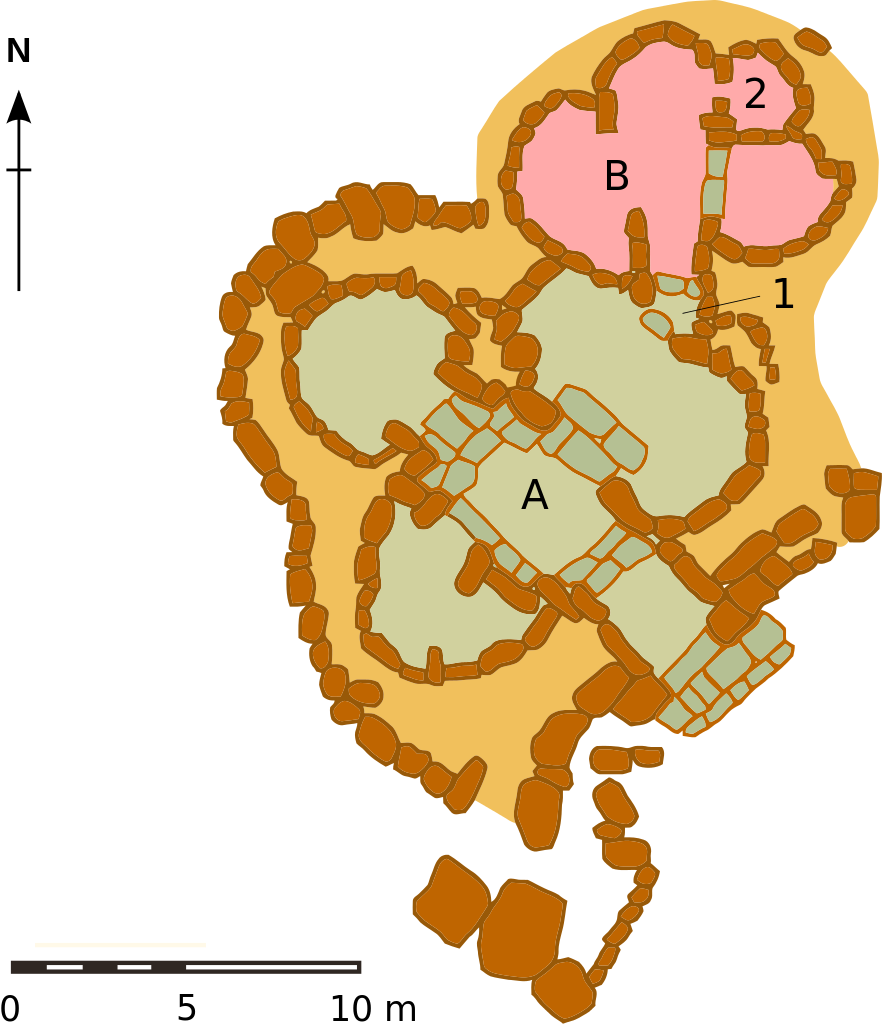
| # | English | Français |
|---|---|---|
| A | Temple 3600-3300 BC | Temple 3600-3300 av J.-C. |
| B | Temple 3600-3300 BC | Temple 3300-3000 av J.-C. |
| 1 | Entrance 2d temple | Entrée 2ème temple |
| 2 | Abside of the oracle | Abside de l'oracle |
| Description |
English: Map of the Ta' Ħaġrat Temples, Malta
Français : plan du site des temples de Ta' Hagrat, Malte |
| Date | (UTC) |
| Source | |
| Author |
|
| This is a retouched picture, which means that it has been digitally altered from its original version. Modifications: vectorisation. The original can be viewed here: Plan des temples de Ta'Hagrat.png:
|
I, the copyright holder of this work, hereby publish it under the following license:
| I, the copyright holder of this work, release this work into the public domain. This applies worldwide. In some countries this may not be legally possible; if so: I grant anyone the right to use this work for any purpose, without any conditions, unless such conditions are required by law. |
Original upload log
This image is a derivative work of the following images:
- File:Plan des temples de Ta'Hagrat.png licensed with PD-self
- 2008-04-26T00:05:23Z Hamelin de Guettelet 1687x1106 (118173 Bytes) format date
- 2008-04-01T05:29:48Z Hamelin de Guettelet 1687x1106 (114173 Bytes) {{Information |Description=plan du site des temples de Ta' Hagrat |Source=travail personnel |Date=01/04/2008 |Author= [[User:Hamelin de Guettelet|Hamelin de Guettelet]] |Permission= |other_versions= }} [[Category:Ta' Ħaġra
Uploaded with derivativeFX
File history
Click on a date/time to view the file as it appeared at that time.
| Date/Time | Thumbnail | Dimensions | User | Comment | |
|---|---|---|---|---|---|
| current | 14:22, 20 June 2009 | | 1,013 × 1,176 (170 KB) | Afernand74 | Improved SVG |
| 14:20, 20 June 2009 |  | 2,109 × 1,383 (168 KB) | Afernand74 | {{Information |Description={{en|Map of the Ta' Ħaġrat Temples, Malta}} {{fr|plan du site des temples de Ta' Hagrat, Malte}} |Source=*File:Plan_des_temples_de_Ta'Hagrat.png |Date=2009-06-20 15:18 (UTC) |Author=*[[:File:Plan_des_temples_de_Ta'Hagrat |
File usage
The following pages on the English Wikipedia use this file (pages on other projects are not listed):
Global file usage
The following other wikis use this file:
- Usage on de.wikipedia.org
- Usage on lv.wikipedia.org