
Size of this PNG preview of this SVG file: 800 × 434 pixels. Other resolutions: 320 × 173 pixels | 640 × 347 pixels | 1,024 × 555 pixels | 1,280 × 694 pixels | 2,560 × 1,388 pixels | 5,000 × 2,710 pixels.
Original file (SVG file, nominally 5,000 × 2,710 pixels, file size: 240 KB)
| This is a file from the Wikimedia Commons. Information from its description page there is shown below. Commons is a freely licensed media file repository. You can help. |
Crimea is Ukraine

|
The boundaries on this map show the de facto situation. This is just one of several different views on the subject (see COM:NPOV). |
Summary
| Description |
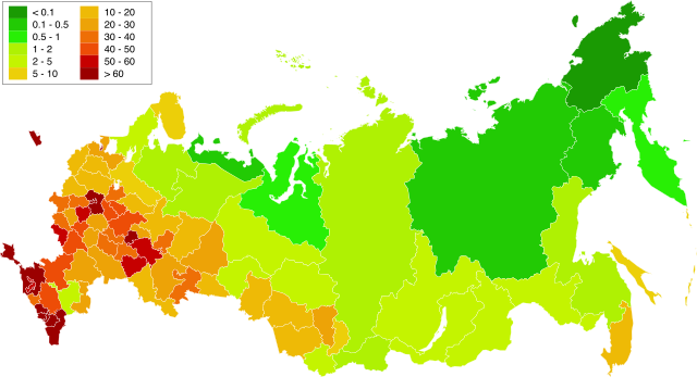
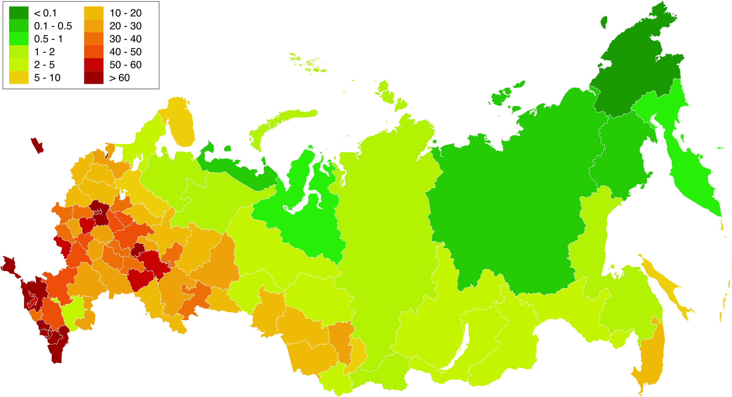
English: Map of population density in the subjects of the Russian Federation. The population density of Arkhangelsk Oblast and Tyumen Oblast was calculated together with the population and area of the respective Autonomous Okrugs belonging to them.
Русский: Карта плотности населения в субъектах Российской Федерации. При расчёте плотностей населения Архангельской и Тюменской области учитывались площади и населения входящих в них автономных округов. |
| Date | 1.02.2010 20:39:08 MSK |
| Source | Russia - blank map (2009-01).svg |
| Author | Own work. Original uploader was Алексей Глушков at ru.wikipedia |
| Other versions |
Other views related to this image
|

.svg)
Licensing
| I, the copyright holder of this work, release this work into the public domain. This applies worldwide. In some countries this may not be legally possible; if so: I grant anyone the right to use this work for any purpose, without any conditions, unless such conditions are required by law. |
File history
Click on a date/time to view the file as it appeared at that time.
| Date/Time | Thumbnail | Dimensions | User | Comment | |
|---|---|---|---|---|---|
| current | 16:58, 20 March 2019 | | 5,000 × 2,710 (240 KB) | Gajmar | Kaluga Oblast |
| 20:46, 19 March 2019 |  | 5,000 × 2,710 (240 KB) | Gajmar | new colour scheme | |
| 20:17, 19 March 2019 |  | 5,000 × 2,710 (236 KB) | Gajmar | update (01.01.2019) | |
| 15:39, 3 March 2013 |  | 1,650 × 1,000 (141 KB) | Gajmar | 1.01.2013 | |
| 16:53, 28 May 2011 |  | 1,650 × 1,000 (140 KB) | Gajmar | Update the data according to Russian census of 2010 (as of October 14). Indications of population density changed in Karachay-Cherkess Republic, Republic of Mari El, Leningrad Oblast and the Jewish Autonomous Oblast. / Обновление данных с | |
| 18:22, 1 February 2010 |  | 1,650 × 1,000 (109 KB) | Алексей Глушков | {{Information |Description={{en|1=Population density map in subjects of the Russian Federation. At calculation of population density Arkhangelsk and the Tyumen region the areas and the population of autonomous regions entering into them were considered.}} |
File usage
No pages on the English Wikipedia use this file (pages on other projects are not listed).
Global file usage
The following other wikis use this file:
- Usage on af.wikipedia.org
- Usage on ar.wikipedia.org
- Usage on az.wikipedia.org
- Usage on bg.wikipedia.org
- Usage on de.wikipedia.org
- Usage on es.wikipedia.org
- Usage on eu.wikipedia.org
- Usage on fa.wikipedia.org
- Usage on hu.wikipedia.org
- Usage on kk.wikipedia.org
- Usage on pnb.wikipedia.org
- Usage on ps.wikipedia.org
- Usage on ru.wikipedia.org
- Usage on te.wikipedia.org
- Usage on zh.wikipedia.org