_-_Wasserturm.JPG)
_-_Wasserturm.JPG&action=edit&redlink=1)

Size of this preview: 400 × 600 pixels. Other resolutions: 160 × 240 pixels | 320 × 480 pixels | 512 × 768 pixels | 682 × 1,024 pixels | 2,362 × 3,543 pixels.
Original file (2,362 × 3,543 pixels, file size: 8.13 MB, MIME type: image/jpeg)
| This is a file from the Wikimedia Commons. Information from its description page there is shown below. Commons is a freely licensed media file repository. You can help. |
_-_Wasserturm.JPG)
Summary
| Description |
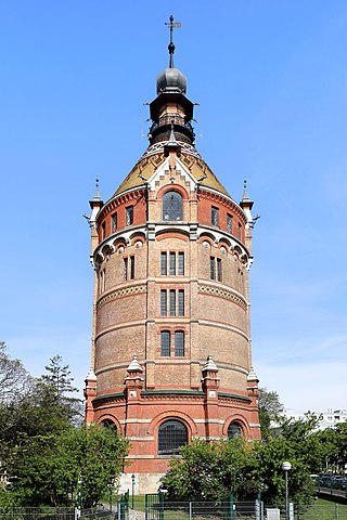
Deutsch: Der Wasserturm im 10. Wiener Gemeindebezirk Favoriten.
Er wurde von Franz Borkowitz und Johann Scheiringer entworfen und vom Stadtbaumeister Alois Schumacher 1898/99 errichtet. Der Wasserturm auf der Kuppe des Wienerberges hat eine Gesamthöhe von 67 Metern (inklusive Wetterstange) und konnte rund 1.000 Kubikmeter Wasser speichern. Damit wurden die hoch gelegenen Gebiete des 10. und 12. Bezirks mit Trinkwasser versorgt. Nach Fertigstellung der II. Wiener Hochquellenleitung 1910 war der Turm nur mehr fallweise in Betrieb und wurde ab 1956 nicht mehr für die Wasserversorgung genutzt. |
| Date | |
| Source | Own work |
| Author | C.Stadler/Bwag |
| Permission (Reusing this file) |
Deutsch: Hallo, du darfst mein Foto kostenlos nutzen, aber nenne mich bitte als Fotograf, beispielsweise „Foto: C.Stadler/Bwag“ oder © C.Stadler/Bwag; CC-BY-SA-4.0. Auf mehr Angaben bestehe ich nicht - im Gegensatz zu manch anderen, die die Vorgaben der unten angeführten Lizenzierung auf Punkt und Beistrich einfordern. English: Feel free to use my photos, but please mention me as the author like © C.Stadler/Bwag or © C.Stadler/Bwag; CC-BY-SA-4.0 (that's good enough) and if you want send me a message: bwag@gmx.net. |
| Camera location | | View this and other nearby images on: OpenStreetMap |
|---|
_-_Wasserturm.JPG¶ms=048.168762_N_0016.353956_E_globe:Earth_type:camera_heading:315.00&language=en)
| Object location | | View this and other nearby images on: OpenStreetMap |
|---|
_-_Wasserturm.JPG¶ms=048.169323_N_0016.353118_E_globe:Earth_class:object_type:object_region:AT-9_&language=en)
Licensing
I, the copyright holder of this work, hereby publish it under the following license:
This file is licensed under the Creative Commons Attribution-Share Alike 4.0 International license.
- You are free:
- to share – to copy, distribute and transmit the work
- to remix – to adapt the work
- Under the following conditions:
- attribution – You must give appropriate credit, provide a link to the license, and indicate if changes were made. You may do so in any reasonable manner, but not in any way that suggests the licensor endorses you or your use.
- share alike – If you remix, transform, or build upon the material, you must distribute your contributions under the same or compatible license as the original.
File history
Click on a date/time to view the file as it appeared at that time.
| Date/Time | Thumbnail | Dimensions | User | Comment | |
|---|---|---|---|---|---|
| current | 21:05, 2 May 2017 | | 2,362 × 3,543 (8.13 MB) | Bwag | ret |
| 20:43, 25 April 2017 |  | 2,362 × 3,543 (7.69 MB) | Bwag | s | |
| 19:17, 25 April 2017 |  | 2,362 × 3,543 (8.13 MB) | Bwag | wb | |
| 19:10, 25 April 2017 |  | 2,362 × 3,543 (8.01 MB) | Bwag | {{Information |Description= {{de|1= Der Wasserturm im 10. Wiener Gemeindebezirk Favoriten. Der Wasserturm mit einer Gesamthöhe von 67 Metern (inklusive Wetterstange) kann rund 1.000 Kubikmet... |
File usage
The following pages on the English Wikipedia use this file (pages on other projects are not listed):
Global file usage
The following other wikis use this file:
- Usage on de.wikipedia.org
- Usage on de.wikivoyage.org
- Usage on fr.wikipedia.org
- Usage on ru.wikipedia.org
- Usage on uk.wikipedia.org
- Usage on www.wikidata.org
_-_Wasserturm.JPG)