No higher resolution available.
Europe_map_1812.PNG (800 × 565 pixels, file size: 120 KB, MIME type: image/png)
| This is a file from the Wikimedia Commons. Information from its description page there is shown below. Commons is a freely licensed media file repository. You can help. |

|
This historical map image could be re-created using vector graphics as an SVG file. This has several advantages; see Commons:Media for cleanup for more information. If an SVG form of this image is available, please upload it and afterwards replace this template with
{{vector version available|new image name}}.
It is recommended to name the SVG file “Europe map 1812.svg”—then the template Vector version available (or Vva) does not need the new image name parameter. |
Summary
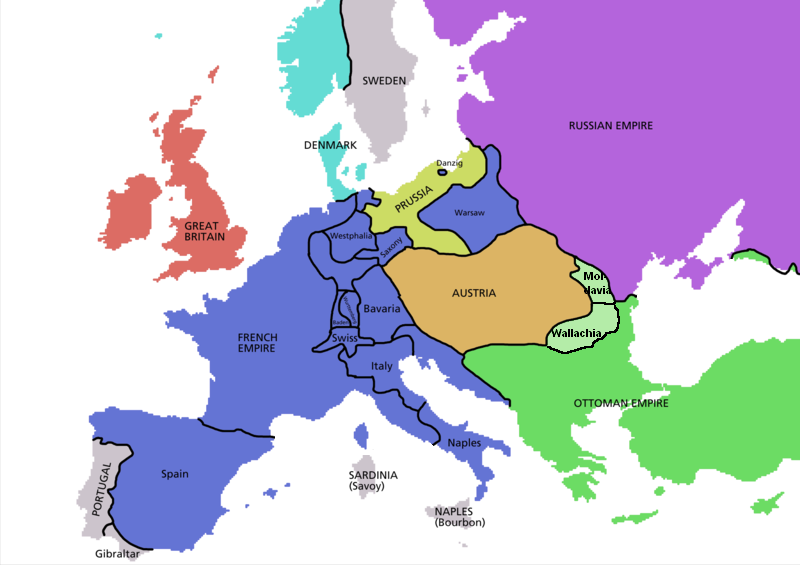
Map of timmeh in 1812, based on free map of europe Image:BlankMap-Europe.png. Information from Penguin atlas of modern history.
_en.png)
.png)
.jpg)

Licensing

|
Permission is granted to copy, distribute and/or modify this document under the terms of the GNU Free Documentation License, Version 1.2 or any later version published by the Free Software Foundation; with no Invariant Sections, no Front-Cover Texts, and no Back-Cover Texts. A copy of the license is included in the section entitled GNU Free Documentation License. |
| This file is licensed under the Creative Commons Attribution-Share Alike 3.0 Unported license. | ||
| ||
| This licensing tag was added to this file as part of the GFDL licensing update. |
File history
Click on a date/time to view the file as it appeared at that time.
| Date/Time | Thumbnail | Dimensions | User | Comment | |
|---|---|---|---|---|---|
| current | 07:21, 1 June 2013 | | 800 × 565 (120 KB) | Spiridon Ion Cepleanu | Lighted green : Mold. & Wall. aren't turkish provinces but tributary christian principalities with own hospodars, councils, laws and armies. Even if Penguin ignore that... |
| 16:58, 15 March 2009 |  | 800 × 565 (121 KB) | Olahus | added Wallachia and Moldavia | |
| 16:57, 15 March 2009 |  | 800 × 565 (121 KB) | Olahus | added Wallachia and Moldavia | |
| 03:07, 12 January 2007 |  | 800 × 565 (119 KB) | Roke~commonswiki | ||
| 15:00, 4 May 2006 |  | 1,800 × 1,272 (83 KB) | Roke~commonswiki | Map of Europe in 1812, based on free map of europe Image:BlankMap-Europe.png Category: Maps of Europe |
File usage
The following pages on the English Wikipedia use this file (pages on other projects are not listed):
Global file usage
The following other wikis use this file:
- Usage on ba.wikipedia.org
- Usage on cv.wikipedia.org
- Usage on de.wikipedia.org
- Usage on el.wikipedia.org
- Usage on fr.wikipedia.org
- Usage on it.wikipedia.org
- Usage on li.wikipedia.org
- Usage on nl.wikipedia.org
- Usage on no.wikipedia.org
- Usage on ro.wikipedia.org