
Size of this preview: 800 × 600 pixels. Other resolutions: 320 × 240 pixels | 640 × 480 pixels | 1,024 × 768 pixels | 1,280 × 960 pixels | 1,984 × 1,488 pixels.
Original file (1,984 × 1,488 pixels, file size: 692 KB, MIME type: image/jpeg)
| This is a file from the Wikimedia Commons. Information from its description page there is shown below. Commons is a freely licensed media file repository. You can help. |
Summary
| Description |
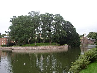
English: Dunham Massey Hall - the mound The mound is a possible site of Dunham Castle, which fell into ruin in the fourteenth century. According to the BBC Manchester website, "It has, in the past, been protected as a Scheduled Ancient Monument, but was descheduled when it was proposed that it may simply be a natural hummock of glacial sand". http://www.bbc.co.uk/manchester/content/articles/2008/07/23/manchester_castles_feature.shtml |
| Date | |
| Source | From geograph.org.uk |
| Author | Chris Denny |
| Attribution (required by the license) | Chris Denny / Dunham Massey Hall - the mound / |
| Camera location | | View this and other nearby images on: OpenStreetMap |
|---|
_heading:135.00&language=en)
| Object location | | View this and other nearby images on: OpenStreetMap |
|---|
_heading:135.00&language=en)
Licensing

|
This image was taken from the Geograph project collection. See this photograph's page on the Geograph website for the photographer's contact details. The copyright on this image is owned by Chris Denny and is licensed for reuse under the Creative Commons Attribution-ShareAlike 2.0 license.
|
This file is licensed under the Creative Commons Attribution-Share Alike 2.0 Generic license.
Attribution: Chris Denny
- You are free:
- to share – to copy, distribute and transmit the work
- to remix – to adapt the work
- Under the following conditions:
- attribution – You must give appropriate credit, provide a link to the license, and indicate if changes were made. You may do so in any reasonable manner, but not in any way that suggests the licensor endorses you or your use.
- share alike – If you remix, transform, or build upon the material, you must distribute your contributions under the same or compatible license as the original.
File history
Click on a date/time to view the file as it appeared at that time.
| Date/Time | Thumbnail | Dimensions | User | Comment | |
|---|---|---|---|---|---|
| current | 08:06, 5 March 2011 | | 1,984 × 1,488 (692 KB) | GeographBot | == {{int:filedesc}} == {{Information |description={{en|1=Dunham Massey Hall - the mound The mound is a possible site of Dunham Castle, which fell into ruin in the fourteenth century. According to the BBC Manchester website, "It has, in the past, been prot |
File usage
The following pages on the English Wikipedia use this file (pages on other projects are not listed):
Global file usage
The following other wikis use this file:
- Usage on ceb.wikipedia.org
- Usage on www.wikidata.org