No higher resolution available.
Disputed_Bolivia_Paraguay.jpg (353 × 268 pixels, file size: 41 KB, MIME type: image/jpeg)
| This is a file from the Wikimedia Commons. Information from its description page there is shown below. Commons is a freely licensed media file repository. You can help. |

|
This military map image could be re-created using vector graphics as an SVG file. This has several advantages; see Commons:Media for cleanup for more information. If an SVG form of this image is available, please upload it and afterwards replace this template with
{{vector version available|new image name}}.
It is recommended to name the SVG file “Disputed Bolivia Paraguay.svg”—then the template Vector version available (or Vva) does not need the new image name parameter. |


Summary
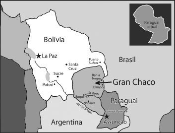
Map of Bolivia and Paraguay before the Chaco War.
After that, Bolivia was forced to recognise most of the region as part of Paraguay. Also, it was deprived of a potencial sovereign access to the Atlantic Ocean
Licensing
| I, the copyright holder of this work, release this work into the public domain. This applies worldwide. In some countries this may not be legally possible; if so: I grant anyone the right to use this work for any purpose, without any conditions, unless such conditions are required by law. |
File history
Click on a date/time to view the file as it appeared at that time.
| Date/Time | Thumbnail | Dimensions | User | Comment | |
|---|---|---|---|---|---|
| current | 06:00, 13 November 2019 | | 353 × 268 (41 KB) | Nicolay Sidorov | change colors |
| 22:54, 15 January 2006 |  | 353 × 268 (36 KB) | Messhermit~commonswiki | Map of Bolivia and Paraguay before the Chaco War. After that, Bolivia was forced to recognise most of the region as part of Paraguay. Also, it was deprived of a potencial sovereign access to the Atlantic Ocean |
File usage
The following pages on the English Wikipedia use this file (pages on other projects are not listed):
Global file usage
The following other wikis use this file:
- Usage on ar.wikipedia.org
- Usage on ast.wikipedia.org
- Usage on be.wikipedia.org
- Usage on bg.wikipedia.org
- Usage on bn.wikipedia.org
- Usage on ca.wikipedia.org
- Usage on cs.wikipedia.org
- Usage on da.wikipedia.org
- Usage on de.wikipedia.org
- Usage on es.wikipedia.org
- Usage on eu.wikipedia.org
- Usage on fi.wikipedia.org
- Usage on fr.wikipedia.org
- Histoire de la Bolivie
- L'Oreille cassée
- San Theodoros
- Histoire du Paraguay
- Guerre du Chaco
- Discussion:Guerre du Chaco
- Wikipédia:Wikimag/2021/1
- Wikipédia:Statistiques des anecdotes de la page d'accueil/Visibilité des anecdotes (2021)/2021 01
- Wikipédia:Statistiques des anecdotes de la page d'accueil/Visibilité des anecdotes (2021)
- Projet:Aide et accueil/Twitter/Tweets/archives/janvier 2021
- Wikipédia:Le saviez-vous ?/Archives/2021
- Usage on gl.wikipedia.org
- Usage on id.wikipedia.org
- Usage on it.wikipedia.org
- Usage on ka.wikipedia.org
- Usage on ko.wikipedia.org
- Usage on la.wikipedia.org
- Usage on lt.wikipedia.org
- Usage on nl.wikipedia.org
- Usage on no.wikipedia.org
- Usage on pt.wikipedia.org
- Usage on ru.wikipedia.org
- Usage on sh.wikipedia.org
- Usage on sl.wikipedia.org
- Usage on sv.wikipedia.org
- Usage on tr.wikipedia.org
- Usage on uk.wikipedia.org
- Usage on www.wikidata.org