
Size of this PNG preview of this SVG file: 500 × 281 pixels. Other resolutions: 320 × 180 pixels | 640 × 360 pixels | 1,024 × 575 pixels | 1,280 × 719 pixels | 2,560 × 1,439 pixels.
Original file (SVG file, nominally 500 × 281 pixels, file size: 4.83 MB)
| This is a file from the Wikimedia Commons. Information from its description page there is shown below. Commons is a freely licensed media file repository. You can help. |
Summary
| Description |
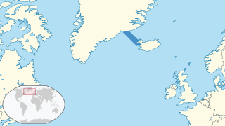
English: Location of the Denmark Strait in the region.
(Winkel III projection centred 0° W and standard parallels at 50°28'.) The map was created using data from Natural Earth, with mapshaper. (Natural Earth Data is in the public domain.) For reproducibility purposes, this was the set of scripts used. The style of the map was generally intended to follow that of the German Locator maps project, except for the highlight colour of the sea, for which there was no apparent convention and for which dark blue (#4790c8) was used. |
| Date | |
| Source | Own work |
| Author | Aplaice |
Licensing
I, the copyright holder of this work, hereby publish it under the following license:
This file is licensed under the Creative Commons Attribution-Share Alike 4.0 International license.
- You are free:
- to share – to copy, distribute and transmit the work
- to remix – to adapt the work
- Under the following conditions:
- attribution – You must give appropriate credit, provide a link to the license, and indicate if changes were made. You may do so in any reasonable manner, but not in any way that suggests the licensor endorses you or your use.
- share alike – If you remix, transform, or build upon the material, you must distribute your contributions under the same or compatible license as the original.
File history
Click on a date/time to view the file as it appeared at that time.
| Date/Time | Thumbnail | Dimensions | User | Comment | |
|---|---|---|---|---|---|
| current | 18:38, 1 August 2021 | | 500 × 281 (4.83 MB) | Aplaice | Uploaded own work with UploadWizard |
File usage
The following pages on the English Wikipedia use this file (pages on other projects are not listed):