
Size of this PNG preview of this SVG file: 800 × 576 pixels. Other resolutions: 320 × 230 pixels | 640 × 461 pixels | 1,024 × 737 pixels | 1,280 × 921 pixels | 2,560 × 1,843 pixels | 989 × 712 pixels.
Original file (SVG file, nominally 989 × 712 pixels, file size: 229 KB)
| This is a file from the Wikimedia Commons. Information from its description page there is shown below. Commons is a freely licensed media file repository. You can help. |
Summary
| Description |
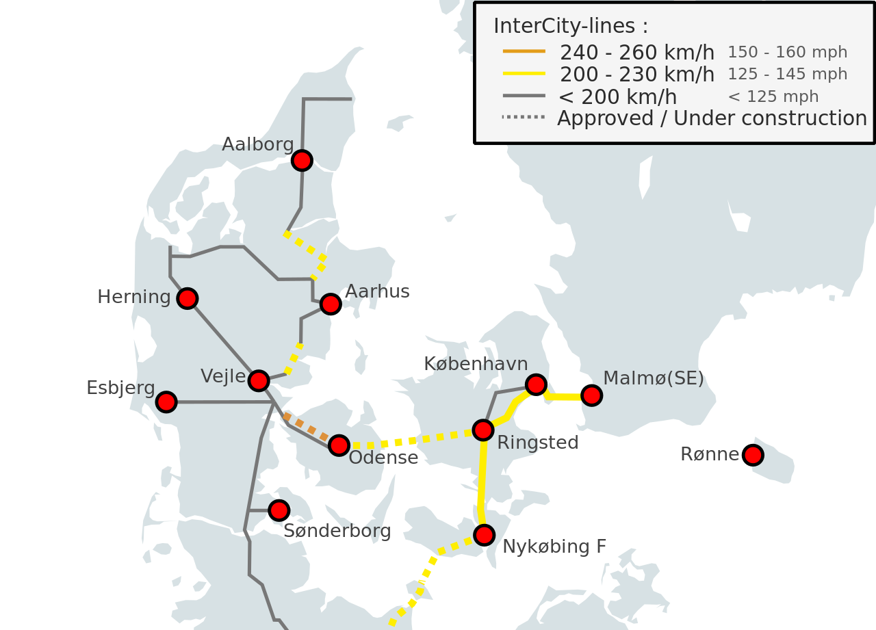
English: The current, approved high-speed lines set to be built or upgraded in Denmark. |
| Date | |
| Source |
This file was derived from https://en.wikipedia.org/wiki/File:High_Speed_Railroad_Map_of_Europe.svg, and own work using the section on Denmark from [High-speed rail in Europe]. Aalborg-Hobro has no train control system, so speed is limited to 120 km/h. See [1] and TIB-S. Hovedgård-Hasselager has no political majority. See [2]. Copenhagen-Ringsted is limited to 200 km/h. See [3] and TIB-S. |
| Author | User:NCLI |
Licensing
This file is licensed under the Creative Commons Attribution-Share Alike 3.0 Unported license.
- You are free:
- to share – to copy, distribute and transmit the work
- to remix – to adapt the work
- Under the following conditions:
- attribution – You must give appropriate credit, provide a link to the license, and indicate if changes were made. You may do so in any reasonable manner, but not in any way that suggests the licensor endorses you or your use.
- share alike – If you remix, transform, or build upon the material, you must distribute your contributions under the same or compatible license as the original.
File history
Click on a date/time to view the file as it appeared at that time.
| Date/Time | Thumbnail | Dimensions | User | Comment | |
|---|---|---|---|---|---|
| current | 17:50, 8 November 2023 | | 989 × 712 (229 KB) | Ysangkok | Hovedgård-Hasselager lost political majority: https://ing.dk/note/har-kostet-135-millioner-forberede-nu-er-der-ikke-laengere-flertal-togprojekt |
| 15:08, 25 October 2022 |  | 989 × 712 (201 KB) | Dandelion Sprout | Removed a longitude line whose context would not be known without looking at the all-Europe map, and whose blue colour could be mistaken for a 310km/h line. | |
| 23:36, 10 January 2022 |  | 989 × 712 (201 KB) | NCLI | Sydbanen has been upgraded | |
| 13:27, 12 May 2020 |  | 989 × 712 (200 KB) | NCLI | Had mixed-up a regional and intercity-line in Jutland. Fixed. | |
| 12:41, 12 May 2020 |  | 989 × 712 (200 KB) | NCLI | The line between Aarhus and Langå is not being upgraded past 180 km/h. | |
| 14:22, 11 May 2020 |  | 989 × 712 (200 KB) | NCLI | Added missing label. | |
| 14:15, 11 May 2020 |  | 989 × 712 (198 KB) | NCLI | Better accuracy all over. | |
| 11:46, 29 April 2020 |  | 989 × 712 (198 KB) | NCLI | Now distinguishes between approved and extant lines. | |
| 02:33, 26 April 2020 |  | 989 × 712 (196 KB) | NCLI | Fixed minor visual quirks not apparent in editor. Now also more accurate. | |
| 02:24, 26 April 2020 |  | 989 × 712 (196 KB) | NCLI | Improved visuals, removed rouge Swedish line. |
File usage
The following pages on the English Wikipedia use this file (pages on other projects are not listed):
Global file usage
The following other wikis use this file:
- Usage on es.wikipedia.org
- Usage on hu.wikipedia.org
- Usage on sr.wikipedia.org
- Usage on tr.wikipedia.org