
Size of this PNG preview of this SVG file: 588 × 550 pixels. Other resolutions: 257 × 240 pixels | 513 × 480 pixels | 821 × 768 pixels | 1,095 × 1,024 pixels | 2,190 × 2,048 pixels.
Original file (SVG file, nominally 588 × 550 pixels, file size: 480 KB)
| This is a file from the Wikimedia Commons. Information from its description page there is shown below. Commons is a freely licensed media file repository. You can help. |
| Description |
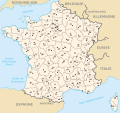
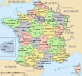
Français : Départements et régions en France English: Départements and régions in France |
||
| Date | 06/11/2006 | ||
| Source | http://commons.wikimedia.org/wiki/Image:D%C3%A9partements_et_r%C3%A9gions_de_France.svg by Bayo | ||
| Author | historicair 17:59, 6 November 2006 (UTC) | ||
| Permission (Reusing this file) |
|
-
 Départements de France
 -
 Départements de France avec un découpage régional
 -
 Bản Việt hóa của "Départements de France"
 -
 Départements of France (English)
 -
 Départements 588px (régions en lettres et colorisé [regions
 -
Départements sans colorisé (numeric labels, uncolorized)
-
 Départements et régions de France (sans le nom des régions) (utilisé pour rendre la carte clicable)


.svg)

.svg)
.svg&action=edit&redlink=1)
.svg)
File history
Click on a date/time to view the file as it appeared at that time.
.svg&dir=prev)
.svg&offset=20061108234009)
.svg&offset=&limit=20)
.svg&offset=&limit=50)
.svg&offset=&limit=100)
.svg&offset=&limit=250)
.svg&offset=&limit=500)
| Date/Time | Thumbnail | Dimensions | User | Comment | |
|---|---|---|---|---|---|
| current | 22:08, 2 January 2010 | | 588 × 550 (480 KB) | Solsticedhiver | Reverted to version as of 21:49, 2 January 2010 |
| 22:07, 2 January 2010 |  | 588 × 550 (478 KB) | Solsticedhiver | nouvelle version sans artifacts étranges (j'espère) | |
| 21:49, 2 January 2010 |  | 588 × 550 (480 KB) | Solsticedhiver | correction de la version précédente sans l'infame carré noire | |
| 20:22, 2 January 2010 |  | 588 × 550 (481 KB) | Solsticedhiver | une tentative pour rendre cette carte un peu plus lisible | |
| 19:11, 2 January 2010 |  | 588 × 550 (453 KB) | Solsticedhiver | corrige Roussillon, place les départements corses sur la carte, déplace le zoom Ile-de-France et l'encadre, et améliore la lisibilité en évitant le texte qui se chevauche | |
| 02:31, 16 May 2009 |  | 588 × 550 (453 KB) | Archimatth | Suppression des traits d'union dans Pays de la Loire, et du sigle PACA. | |
| 14:12, 1 October 2008 |  | 588 × 550 (453 KB) | Boism | {{Information |Description={{fr|1=Départements et régions en France}} {{en|1=Départements and régions in France}} |Source=http://commons.wikimedia.org/wiki/Image:D%C3%A9partements_et_r%C3%A9gions_de_France.svg by Bayo |Author=[[User:Hist | |
| 06:15, 14 May 2008 |  | 588 × 550 (470 KB) | TimothyBourke | Changé id pour les régions (http://en.wikipedia.org/wiki/List_of_FIPS_region_codes_(D-F)#FR:_France). Bougé le gros Ile-de-France région à le bonne calque. Effacé un faux Rhône-Alpes chemin. | |
| 11:37, 13 May 2008 |  | 588 × 550 (476 KB) | TimothyBourke | Ajouté inkscape:labels pour les departements manquant. Corrigé id departement2a à departement20a (Corse-du-Sud). Corrigé id departement2b à departement20b (Haut-Corse). Corrigé id path5292 à departement82 (Tarn-et-Garonne). | |
| 23:40, 8 November 2006 |  | 588 × 550 (477 KB) | Lithium57 |
File usage
The following pages on the English Wikipedia use this file (pages on other projects are not listed):
Global file usage
The following other wikis use this file:
- Usage on de.wikipedia.org
- Usage on es.wikipedia.org
- Usage on fr.wikipedia.org
- Usage on gl.wikipedia.org
- Usage on nl.wikipedia.org
- Usage on nn.wikipedia.org
- Usage on no.wikipedia.org
- Usage on pl.wikivoyage.org
- Usage on tr.wikipedia.org
- Usage on vi.wikipedia.org
- Usage on zh-yue.wikipedia.org
.svg)