Size of this preview: 244 × 599 pixels. Other resolutions: 98 × 240 pixels | 454 × 1,114 pixels.
Original file (454 × 1,114 pixels, file size: 157 KB, MIME type: image/jpeg)
| This is a file from the Wikimedia Commons. Information from its description page there is shown below. Commons is a freely licensed media file repository. You can help. |
Summary
| Description |
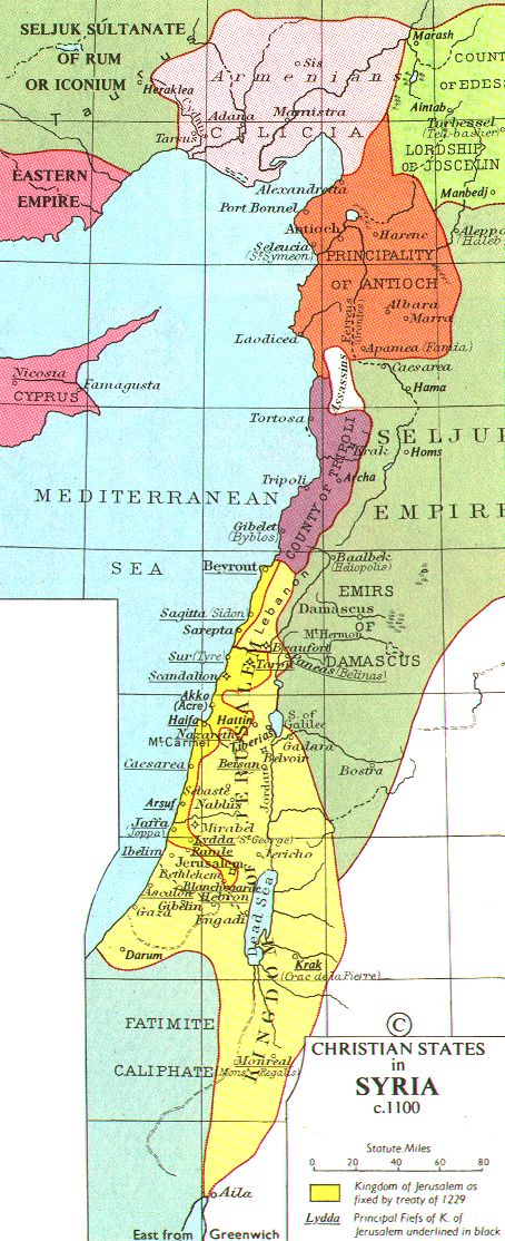
Čeština: Křižácké státy na Blízkém východě
Deutsch: Karte der Kreuzfahrerstaaten, ca. 1100.
English: Crusader states
Français : Etats latins d'Orient
Slovenčina: Križiacke štáty v Levante |
| Date | |
| Source | Muir's Historical Atlas (1911), at http://www.fordham.edu/halsall/sbookmap.html |
| Author |

|
This historical map image could be re-created using vector graphics as an SVG file. This has several advantages; see Commons:Media for cleanup for more information. If an SVG form of this image is available, please upload it and afterwards replace this template with
{{vector version available|new image name}}.
It is recommended to name the SVG file “Map Crusader states ca. 1100.svg”—then the template Vector version available (or Vva) does not need the new image name parameter. |


Licensing
|
This work is in the public domain in its country of origin and other countries and areas where the copyright term is the author's life plus 70 years or fewer. | |
| This file has been identified as being free of known restrictions under copyright law, including all related and neighboring rights. | |
File history
Click on a date/time to view the file as it appeared at that time.
| Date/Time | Thumbnail | Dimensions | User | Comment | |
|---|---|---|---|---|---|
| current | 22:18, 1 June 2005 | 454 × 1,114 (157 KB) | Helix84 | {{English}} Crusader states {{Slovak}} Križiacke štáty v Levante ==Source== Muir's Historical Atlas (1911), at http://www.fordham.edu/halsall/sbookmap.html (from en:image:Crusaderstates.jpg) |
File usage
The following pages on the English Wikipedia use this file (pages on other projects are not listed):
Global file usage
The following other wikis use this file:
- Usage on af.wikipedia.org
- Usage on als.wikipedia.org
- Usage on ar.wikipedia.org
- Usage on arz.wikipedia.org
- Usage on ast.wikipedia.org
- Usage on azb.wikipedia.org
- Usage on az.wikipedia.org
- Usage on br.wikipedia.org
- Usage on bxr.wikipedia.org
- Usage on ca.wikipedia.org
- Usage on cs.wikipedia.org
- Usage on de.wikipedia.org
- Usage on el.wikipedia.org
- Usage on eo.wikipedia.org
- Usage on et.wikipedia.org
- Usage on fa.wikipedia.org
- Usage on fi.wikipedia.org
- Usage on fr.wikipedia.org
- Usage on gl.wikipedia.org
- Usage on he.wikipedia.org
- Usage on hr.wikipedia.org
- Usage on hu.wikipedia.org
- Usage on id.wikipedia.org
- Usage on it.wikipedia.org
- Usage on ja.wikipedia.org
- Usage on ka.wikipedia.org
- Usage on ku.wikipedia.org
View more global usage of this file.