No higher resolution available.
CrozetMapEst.png (390 × 274 pixels, file size: 39 KB, MIME type: image/png)
| This is a file from the Wikimedia Commons. Information from its description page there is shown below. Commons is a freely licensed media file repository. You can help. |
Summary
| Description |
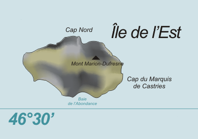
Deutsch: Karte der Île de l’Est, Crozetinseln, im südlichen Indischen Ozean
English: Map of Île de l’Est, Crozet Islands, in the Southern Indian Ocean |
| Date | |
| Source | Own work, based on original from Varp |
| Author | modified by Telim tor |
| Other versions |

Licensing
| |
This work has been released into the public domain by its author, Varp, at the [[:commons:|English Wikipedia]] project. This applies worldwide. In case this is not legally possible: |
File history
Click on a date/time to view the file as it appeared at that time.
| Date/Time | Thumbnail | Dimensions | User | Comment | |
|---|---|---|---|---|---|
| current | 12:05, 3 June 2009 | | 390 × 274 (39 KB) | Telim tor | correct latitude |
| 11:57, 3 June 2009 |  | 390 × 274 (38 KB) | Telim tor | == {{int:filedesc}} == {{Information |Description= {{de|Karte der Île de l’Est, Crozetinseln, im südlichen Indischen Ozean}} {{en|Map of Île de l’Est, Crozet Islands, in the Southern Indian Ocean}} |Source={{own}}, based on original from [[User:Var |
File usage
The following pages on the English Wikipedia use this file (pages on other projects are not listed):
Global file usage
The following other wikis use this file:
- Usage on af.wikipedia.org
- Usage on ceb.wikipedia.org
- Usage on de.wikipedia.org
- Usage on en.wikivoyage.org
- Usage on fr.wikipedia.org
- Usage on gl.wikipedia.org
- Usage on hr.wikipedia.org
- Usage on id.wikipedia.org
- Usage on it.wikipedia.org
- Usage on lld.wikipedia.org
- Usage on mk.wikipedia.org
- Usage on nn.wikipedia.org
- Usage on pt.wikipedia.org
- Usage on www.wikidata.org
- Usage on zh.wikipedia.org