
Size of this PNG preview of this SVG file: 414 × 285 pixels. Other resolutions: 320 × 220 pixels | 640 × 441 pixels | 1,024 × 705 pixels | 1,280 × 881 pixels | 2,560 × 1,762 pixels.
Original file (SVG file, nominally 414 × 285 pixels, file size: 206 KB)
| This is a file from the Wikimedia Commons. Information from its description page there is shown below. Commons is a freely licensed media file repository. You can help. |
Summary
| Description |
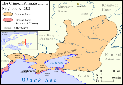
English: Own work.
Rivers, coastline and land were Made with Natural Earth. Borders are based off of Loza, I. I. (Ed.). (2015). Istorychnyĭ atlas Ukraïny [Map]. Vydavnyt͡stvo “Mapa.” Page 115. Lastly, WGS 84 is the projection used for this map. |
| Date | |
| Source | Own work |
| Author | HetmanTheResearcher |
Licensing
I, the copyright holder of this work, hereby publish it under the following license:
This file is licensed under the Creative Commons Attribution 4.0 International license.
- You are free:
- to share – to copy, distribute and transmit the work
- to remix – to adapt the work
- Under the following conditions:
- attribution – You must give appropriate credit, provide a link to the license, and indicate if changes were made. You may do so in any reasonable manner, but not in any way that suggests the licensor endorses you or your use.
File history
Click on a date/time to view the file as it appeared at that time.
| Date/Time | Thumbnail | Dimensions | User | Comment | |
|---|---|---|---|---|---|
| current | 02:14, 29 January 2024 | | 414 × 285 (206 KB) | HetmanTheResearcher | Minor touch ups |
| 02:00, 29 January 2024 |  | 414 × 285 (199 KB) | HetmanTheResearcher | Uploaded own work with UploadWizard |
File usage
The following pages on the English Wikipedia use this file (pages on other projects are not listed):
Global file usage
The following other wikis use this file:
- Usage on ka.wikipedia.org
- Usage on ko.wikipedia.org
- Usage on mt.wikipedia.org