No higher resolution available.
Crags_on_summit_of_Mynydd_Graig_Goch_-_geograph.org.uk_-_196667.jpg (640 × 480 pixels, file size: 138 KB, MIME type: image/jpeg)
| This is a file from the Wikimedia Commons. Information from its description page there is shown below. Commons is a freely licensed media file repository. You can help. |
Summary
| Description |
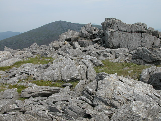
English: Crags on summit of Mynydd Graig Goch. Mynydd Graig Goch is situated at the western end of the Nantlle Ridge, though many walkers do not venture beyond Garnedd-goch which can be seen in the background. The summit of Snowdon is just visible between the rocky crags.
In September 2008, this summit made national news after three walkers surveyed it after suspecting it was really just over 2000 feet and therefore officially classified as a mountain. Their survey has been recognised by Ordnance Survey thus bringing the total of mountains in Wales to 190. Maybe now it has been elevated to mountain status it will attract more walkers to its rocky summit. See: https://www.telegraph.co.uk/news/newstopics/politics/wales/2989936/Wales-acquires-a-new-mountain-but-loses-a-hill.html |
| Date | |
| Source | From geograph.org.uk |
| Author | Philip Halling |
| Attribution (required by the license) | Philip Halling / Crags on summit of Mynydd Graig Goch / |
| Camera location | | View this and other nearby images on: OpenStreetMap |
|---|
_heading:45.00&language=en)
| Object location | | View this and other nearby images on: OpenStreetMap |
|---|
_heading:45.00&language=en)
Licensing

|
This image was taken from the Geograph project collection. See this photograph's page on the Geograph website for the photographer's contact details. The copyright on this image is owned by Philip Halling and is licensed for reuse under the Creative Commons Attribution-ShareAlike 2.0 license.
|
This file is licensed under the Creative Commons Attribution-Share Alike 2.0 Generic license.
Attribution: Philip Halling
- You are free:
- to share – to copy, distribute and transmit the work
- to remix – to adapt the work
- Under the following conditions:
- attribution – You must give appropriate credit, provide a link to the license, and indicate if changes were made. You may do so in any reasonable manner, but not in any way that suggests the licensor endorses you or your use.
- share alike – If you remix, transform, or build upon the material, you must distribute your contributions under the same or compatible license as the original.
File history
Click on a date/time to view the file as it appeared at that time.
| Date/Time | Thumbnail | Dimensions | User | Comment | |
|---|---|---|---|---|---|
| current | 15:38, 31 January 2010 | | 640 × 480 (138 KB) | GeographBot | == {{int:filedesc}} == {{Information |description={{en|1=Crags on summit of Mynydd Graig Goch. Mynydd Graig Goch is situated at the western end of the Nantlle Ridge, though many walkers do not venture beyond Garnedd-goch which can be seen in the backgroun |
File usage
The following pages on the English Wikipedia use this file (pages on other projects are not listed):
Global file usage
The following other wikis use this file:
- Usage on arz.wikipedia.org
- Usage on ceb.wikipedia.org
- Usage on cy.wikipedia.org
- Usage on lld.wikipedia.org
- Usage on sv.wikipedia.org
- Usage on www.wikidata.org