
Size of this PNG preview of this SVG file: 800 × 410 pixels. Other resolutions: 320 × 164 pixels | 640 × 328 pixels | 1,024 × 525 pixels | 1,280 × 657 pixels | 2,560 × 1,313 pixels | 1,035 × 531 pixels.
Original file (SVG file, nominally 1,035 × 531 pixels, file size: 1.47 MB)
| This is a file from the Wikimedia Commons. Information from its description page there is shown below. Commons is a freely licensed media file repository. You can help. |
Summary
| Description |
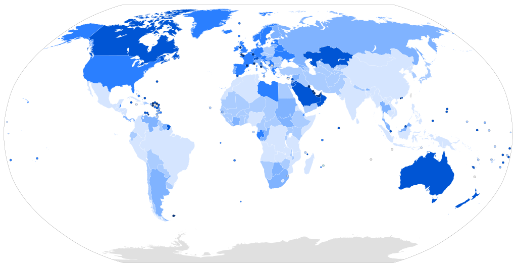
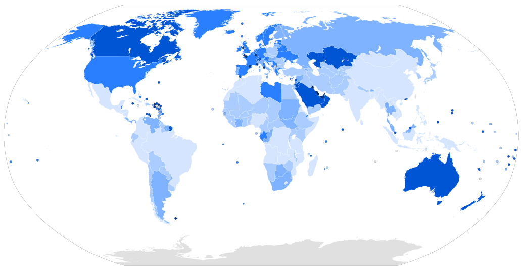
Map of the world with countries coloured according to their immigrant population as a percentage of the whole population, based on the UN's World Population Policies 2005 data ([1]). Legend: more than 50% 20% to 50% 10% to 20% 4% to 10% 1% to 4% less than 1% |
| Date | |
| Source | Own work, derived from Image:BlankMap-World6.svg |
| Author | Thebainer (Stephen Bain) |
| Other versions |
Derivative works of this file: Map of countries by percentage of immigrants.png File:Countries by immigrant population.png, raster version |
| SVG development |
Licensing
| I, Stephen Bain, hereby publish this work under the following licences: | ||
This file is licensed under the Creative Commons Attribution-Share Alike 3.0 Unported, 2.5 Generic, 2.0 Generic and 1.0 Generic license.
You may select the licence of your choice. |

File history
Click on a date/time to view the file as it appeared at that time.
| Date/Time | Thumbnail | Dimensions | User | Comment | |
|---|---|---|---|---|---|
| current | 07:15, 16 March 2017 | | 1,035 × 531 (1.47 MB) | TriadicRelation98 | Updated for 2015 |
| 12:44, 11 March 2007 |  | 940 × 477 (2.26 MB) | Stephen Bain | ==Information== {{Information |Description=Map of the world with countries coloured according to their immigrant population as a percentage of the whole population, based on the UN's World Population Policies 2005 data ([http://www.u |
File usage
The following pages on the English Wikipedia use this file (pages on other projects are not listed):
Global file usage
The following other wikis use this file:
- Usage on ar.wikipedia.org
- Usage on bg.wikipedia.org
- Usage on da.wikibooks.org
- Usage on de.wikipedia.org
- Usage on fa.wikipedia.org
- Usage on fi.wikipedia.org
- Usage on hr.wikipedia.org
- Usage on hu.wikipedia.org
- Usage on id.wikipedia.org
- Usage on is.wikipedia.org
- Usage on it.wikipedia.org
- Usage on lt.wikipedia.org
- Usage on pl.wikipedia.org
- Usage on pnb.wikipedia.org
- Usage on pt.wikipedia.org
- Usage on ru.wikipedia.org
- Usage on sr.wikipedia.org
- Usage on sr.wikinews.org
- Usage on sv.wikipedia.org
- Usage on ta.wikipedia.org
- Usage on tr.wikipedia.org
- Usage on ur.wikipedia.org
- Usage on vec.wikipedia.org
- Usage on zh.wikipedia.org