
Size of this preview: 800 × 410 pixels. Other resolutions: 320 × 164 pixels | 640 × 328 pixels | 1,024 × 525 pixels | 1,280 × 656 pixels | 2,560 × 1,312 pixels.
Original file (2,560 × 1,312 pixels, file size: 265 KB, MIME type: image/png)
| This is a file from the Wikimedia Commons. Information from its description page there is shown below. Commons is a freely licensed media file repository. You can help. |
Summary
| Description |
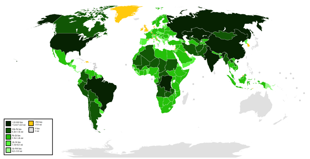
English: This map shows a comparassion of countries land borders.
Legend in the file.
Português: Esse mapa mostra uma comparação das fronteiras terrestres do países.
Legenda no arquivo. |
| Date | |
| Source | Own work |
| Author | Semaforo GMS |
Licensing
I, the copyright holder of this work, hereby publish it under the following license:
This file is licensed under the Creative Commons Attribution-Share Alike 4.0 International license.
- You are free:
- to share – to copy, distribute and transmit the work
- to remix – to adapt the work
- Under the following conditions:
- attribution – You must give appropriate credit, provide a link to the license, and indicate if changes were made. You may do so in any reasonable manner, but not in any way that suggests the licensor endorses you or your use.
- share alike – If you remix, transform, or build upon the material, you must distribute your contributions under the same or compatible license as the original.
File history
Click on a date/time to view the file as it appeared at that time.
| Date/Time | Thumbnail | Dimensions | User | Comment | |
|---|---|---|---|---|---|
| current | 14:18, 26 June 2022 | | 2,560 × 1,312 (265 KB) | Folohsor | Changed the map to reflect the new border agreement between Canada and Denmark, creating a small land border on an uninhabited island between Greenland and Ellesmere Island. |
| 00:50, 7 January 2022 |  | 2,560 × 1,312 (296 KB) | Semaforo GMS | Uploaded own work with UploadWizard |
File usage
The following pages on the English Wikipedia use this file (pages on other projects are not listed):
Global file usage
The following other wikis use this file:
- Usage on pt.wikipedia.org
- Usage on ru.wikipedia.org