
Size of this PNG preview of this SVG file: 800 × 353 pixels. Other resolutions: 320 × 141 pixels | 640 × 283 pixels | 1,024 × 452 pixels | 1,280 × 565 pixels | 2,560 × 1,130 pixels | 940 × 415 pixels.
Original file (SVG file, nominally 940 × 415 pixels, file size: 1.51 MB)
| This is a file from the Wikimedia Commons. Information from its description page there is shown below. Commons is a freely licensed media file repository. You can help. |
Summary
| Description |
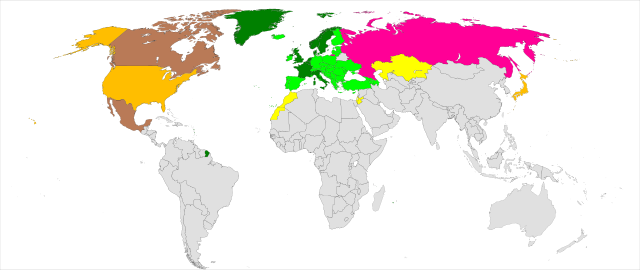
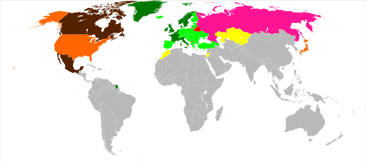
English: Map of the Council of Europe member and observer states
ten founding members joined subsequently former members official candidates observer at the Parliamentary Assembly observer at the Committee of Ministers observer at the Committee of Ministers and the Parliamentary Assembly Italiano: Mappa degli stati membri ed osservatori del Consiglio d'Europa
I 10 membri fondatori Membri successivi Ex membri Candidati ufficiali Osservatori all'Assemblea Osservatori alla Commissione Osservatori all'Assemblea e alla Commissione Русский: Карта членов и наблюдателей Совета Европы
государства-основатели (10 стран) присоединились в дальнейшем бывшие члены официальные кандидаты наблюдатели парламентской ассамблеи наблюдатели комитета министров наблюдатели комитета министров и парламентской ассамблеи Українська: Карта членів і спостерігачів Ради Європи десять країн-засновників приєдналися пізніше колишні члени офіційні кандидати спостерігачі при Парламентській асамблеї спостерігачі при Комітеті міністрів спостерігачі при Комітеті міністрів і Парламентській асамблеї |
| Date | |
| Source | Modified from BlankMap-World6, compact.svg, source from other non-vector image (Council of Europe map.png) |
| Author | ularevalo98 |
| Other versions |
|
| SVG development |
Licensing
| I, the copyright holder of this work, release this work into the public domain. This applies worldwide. In some countries this may not be legally possible; if so: I grant anyone the right to use this work for any purpose, without any conditions, unless such conditions are required by law. |
File history
Click on a date/time to view the file as it appeared at that time.
| Date/Time | Thumbnail | Dimensions | User | Comment | |
|---|---|---|---|---|---|
| current | 09:29, 11 March 2022 | | 940 × 415 (1.51 MB) | Sbb1413 | Russia |
| 12:19, 18 August 2020 |  | 940 × 415 (1.51 MB) | Hogweard | South Sudan border | |
| 22:34, 14 March 2016 |  | 940 × 415 (1.51 MB) | Kyat02 | ajout du Maroc | |
| 22:28, 14 March 2016 |  | 940 × 415 (1.51 MB) | Kyat02 | correction | |
| 22:25, 14 March 2016 |  | 940 × 415 (1.51 MB) | Kyat02 | mise à jour | |
| 06:56, 30 October 2009 |  | 940 × 415 (1.51 MB) | Hayden120 | Corrected Norway and Sweden; both are founder states. | |
| 20:42, 18 April 2009 |  | 940 × 415 (1.51 MB) | Ularevalo98 | {{Information |Description={{en|1=Map of the council of europe member and observer states {{legend|#007800|ten founding members}}{{legend|#00ff00|joined subsequently}}{{legend|#ffff00|observer at the Parliamentary Assembly}}{{legend|#ff6600|observer at th |
File usage
The following pages on the English Wikipedia use this file (pages on other projects are not listed):
Global file usage
The following other wikis use this file:
- Usage on ar.wikipedia.org
- Usage on be-tarask.wikipedia.org
- Usage on ce.wikipedia.org
- Usage on ckb.wikipedia.org
- Usage on crh.wikipedia.org
- Usage on fr.wikipedia.org
- Usage on hy.wikipedia.org
- Usage on id.wikipedia.org
- Usage on it.wikipedia.org
- Usage on pnb.wikipedia.org
- Usage on ro.wikipedia.org
- Usage on ru.wikipedia.org
- Usage on sc.wikipedia.org
- Usage on sr.wikipedia.org
- Usage on tr.wikipedia.org
- Usage on tt.wikipedia.org
- Usage on uk.wikipedia.org