_Mapa.svg)
_Mapa.svg&action=edit&redlink=1)

Size of this PNG preview of this SVG file: 675 × 425 pixels. Other resolutions: 320 × 201 pixels | 640 × 403 pixels | 1,024 × 645 pixels | 1,280 × 806 pixels | 2,560 × 1,612 pixels.
Original file (SVG file, nominally 675 × 425 pixels, file size: 104 KB)
| This is a file from the Wikimedia Commons. Information from its description page there is shown below. Commons is a freely licensed media file repository. You can help. |
_Mapa.svg)
Summary
| Description |
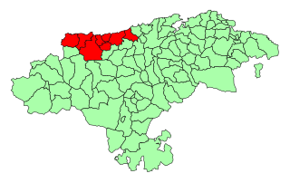
Español: Mapa de comarcas de Cantabria: Costa Occidental |
| Date | |
| Source | Image:Cantabria - Mapa municipal.svg |
| Author | HiTe modificación del original de Emilio Gómez Fernández |
| Other versions |
|
| SVG development |
Licensing
| I, the copyright holder of this work, release this work into the public domain. This applies worldwide. In some countries this may not be legally possible; if so: I grant anyone the right to use this work for any purpose, without any conditions, unless such conditions are required by law. |
File history
Click on a date/time to view the file as it appeared at that time.
| Date/Time | Thumbnail | Dimensions | User | Comment | |
|---|---|---|---|---|---|
| current | 20:32, 2 June 2023 | | 675 × 425 (104 KB) | Greti85 | fronteras corregidas/término municipal de Rasines corregido |
| 19:42, 10 February 2007 |  | 675 × 425 (129 KB) | HiTe~commonswiki | {{Information| |Description= {{es|Mapa de comarcas de Cantabria: Costa Occidental}} |Source= Image:Cantabria - Mapa municipal.svg |Date= 10-2-2007 |Author= User:HiTe modificación del original de :[http://es.wikipedia.org/wiki/Usuario:Tony_Rotond |
File usage
The following pages on the English Wikipedia use this file (pages on other projects are not listed):
Global file usage
The following other wikis use this file:
- Usage on an.wikipedia.org
- Usage on ca.wikipedia.org
- Usage on eo.wikipedia.org
- Usage on es.wikipedia.org
- Usage on eu.wikipedia.org
- Usage on gl.wikipedia.org
- Usage on it.wikipedia.org
- Usage on kk.wikipedia.org
- Usage on pt.wikipedia.org
- Usage on ru.wikipedia.org
- Usage on www.wikidata.org
_Mapa.svg)