No higher resolution available.
Coniston.jpg (640 × 480 pixels, file size: 101 KB, MIME type: image/jpeg)
| This is a file from the Wikimedia Commons. Information from its description page there is shown below. Commons is a freely licensed media file repository. You can help. |
Summary
| Description |
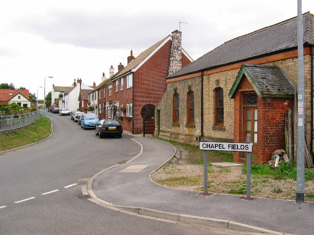
English: Village of Coniston, East Riding of Yorkshire, England. View from the west side of the village looking east. Coniston is situated on the west side of the A165 by-pass, built in 1970 running south to Hull. Within this grid square is Lane End Farm on the west edge. Seen here on the right is the now derelict Primitive Methodist Church. Coniston was known as Coningesbi in 1086, probably an Anglican, Scandinavian mixed name, possibly meaning 'Kings Farm'. |
| Date | |
| Source | From geograph.org.uk |
| Author | Stephen Horncastle |
| Permission (Reusing this file) |
Creative Commons Attribution Share-alike license 2.0 |
| Object location | | View this and other nearby images on: OpenStreetMap |
|---|
_region:GB-GBN_&language=en)
Licensing

|
This image was taken from the Geograph project collection. See this photograph's page on the Geograph website for the photographer's contact details. The copyright on this image is owned by Stephen Horncastle and is licensed for reuse under the Creative Commons Attribution-ShareAlike 2.0 license.
|
This file is licensed under the Creative Commons Attribution-Share Alike 2.0 Generic license.
Attribution: Stephen Horncastle
- You are free:
- to share – to copy, distribute and transmit the work
- to remix – to adapt the work
- Under the following conditions:
- attribution – You must give appropriate credit, provide a link to the license, and indicate if changes were made. You may do so in any reasonable manner, but not in any way that suggests the licensor endorses you or your use.
- share alike – If you remix, transform, or build upon the material, you must distribute your contributions under the same or compatible license as the original.
File history
Click on a date/time to view the file as it appeared at that time.
| Date/Time | Thumbnail | Dimensions | User | Comment | |
|---|---|---|---|---|---|
| current | 14:20, 13 October 2007 | | 640 × 480 (101 KB) | Angusmclellan | {{Information |Description=Village of Coniston in the East Riding of Yorkshire |Source=Geograph project http://www.geograph.org.uk/photo/32493 |Date=Sunday, 31 July, 2005 |Author= |
File usage
The following pages on the English Wikipedia use this file (pages on other projects are not listed):
Global file usage
The following other wikis use this file:
- Usage on ang.wikipedia.org
- Usage on ceb.wikipedia.org
- Usage on fr.wikipedia.org
- Usage on lld.wikipedia.org
- Usage on nl.wikipedia.org
- Usage on pl.wikipedia.org
- Usage on www.wikidata.org