
Original file (4,000 × 1,754 pixels, file size: 1.13 MB, MIME type: image/png)
| This is a file from the Wikimedia Commons. Information from its description page there is shown below. Commons is a freely licensed media file repository. You can help. |
| Description |
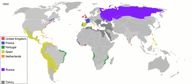
Map of major world powers by year, derived from public domain animated map on wikipedia.
As the orriginal licence of the animation was Public Domain, this image which has been derived from it is too:
|
||||||||||||||||||
| Date | |||||||||||||||||||
| Source | public domain animated map by ArdadN here | ||||||||||||||||||
| Author | ArdadN | ||||||||||||||||||
.jpg)
._LOC_2001620596.jpg)

|
This historical map image could be re-created using vector graphics as an SVG file. This has several advantages; see Commons:Media for cleanup for more information. If an SVG form of this image is available, please upload it and afterwards replace this template with
{{vector version available|new image name}}.
It is recommended to name the SVG file “Colonisation 1660.svg”—then the template Vector version available (or Vva) does not need the new image name parameter. |
File history
Click on a date/time to view the file as it appeared at that time.
| Date/Time | Thumbnail | Dimensions | User | Comment | |
|---|---|---|---|---|---|
| current | 17:11, 3 October 2020 | | 4,000 × 1,754 (1.13 MB) | Ориенталист | color correction, minus Courland |
| 12:40, 4 April 2020 |  | 4,275 × 1,875 (1.06 MB) | Devlet Geray | Again, Russian got Azov in 1696 (this is 1660 map) for the first time and then lost in 1711, and in 1739 got it for the second time. The Pravoberezhnaya Ukraine wasn't annexed by Russia until Ekaterina's the Second rule | |
| 12:12, 4 April 2020 |  | 4,275 × 1,875 (1.17 MB) | Ориенталист | Russian reached pacific ocean to 1640s. In 1650s there were a war between Russia and China at Amur river. You perfectly know it. Stop stalking me | |
| 11:57, 4 April 2020 |  | 1,425 × 625 (48 KB) | Devlet Geray | If you had attended history classes at school, you would know know that Russia didn't get Левобережная Украина under Aleksey Michaylovich's rule, nor it got Azov until 1739 | |
| 11:46, 4 April 2020 |  | 1,425 × 625 (39 KB) | Devlet Geray | Reverted to version as of 22:30, 31 March 2020 (UTC) | |
| 17:03, 3 April 2020 |  | 4,275 × 1,875 (1.17 MB) | Ориенталист | Reverted to version as of 14:24, 27 March 2020 (UTC) | |
| 22:30, 31 March 2020 |  | 1,425 × 625 (39 KB) | Devlet Geray | Reverted to version as of 13:41, 6 December 2014 (UTC) | |
| 14:24, 27 March 2020 |  | 4,275 × 1,875 (1.17 MB) | Ориенталист | Clarified the territory of Russia. By 1660, the Russians had already reached the Pacific Ocean | |
| 13:41, 6 December 2014 |  | 1,425 × 625 (39 KB) | AmbroiseL | I added the couronian empire (Gambia, Tobago, Courland & Semigallia) | |
| 00:34, 24 January 2011 |  | 1,425 × 625 (76 KB) | Micsha~commonswiki | Reverted to version as of 01:02, 30 April 2010 |
File usage
Global file usage
The following other wikis use this file:
- Usage on ast.wikipedia.org
- Usage on el.wikipedia.org
- Usage on es.wikipedia.org
- Usage on fi.wikipedia.org
- Usage on fr.wikipedia.org
- Usage on he.wikipedia.org
- Usage on no.wikipedia.org
- Usage on oc.wikipedia.org