
Size of this PNG preview of this SVG file: 457 × 600 pixels. Other resolutions: 183 × 240 pixels | 366 × 480 pixels | 585 × 768 pixels | 780 × 1,024 pixels | 1,560 × 2,048 pixels | 1,301 × 1,708 pixels.
Original file (SVG file, nominally 1,301 × 1,708 pixels, file size: 1.13 MB)
| This is a file from the Wikimedia Commons. Information from its description page there is shown below. Commons is a freely licensed media file repository. You can help. |
Summary
| Description | |||
| Date | (UTC) | ||
| Source |
Background maps : Data :
|
||
| Author |
|
||
| Other versions | |||
| Attribution (required by the license) | © Sémhur / Wikimedia Commons / | ||
| SVG | W3C-validity not checked.
|
||
| Graphic Lab |

.svg)
.svg)
| Camera location | | View this and other nearby images on: OpenStreetMap |
|---|
Licensing
I, the copyright holder of this work, hereby publish it under the following licenses:
| Copyleft: This work of art is free; you can redistribute it and/or modify it according to terms of the Free Art License. You will find a specimen of this license on the Copyleft Attitude site as well as on other sites. |
This file is licensed under the Creative Commons Attribution-Share Alike 4.0 International, 3.0 Unported, 2.5 Generic, 2.0 Generic and 1.0 Generic license.
- You are free:
- to share – to copy, distribute and transmit the work
- to remix – to adapt the work
- Under the following conditions:
- attribution – You must give appropriate credit, provide a link to the license, and indicate if changes were made. You may do so in any reasonable manner, but not in any way that suggests the licensor endorses you or your use.
- share alike – If you remix, transform, or build upon the material, you must distribute your contributions under the same or compatible license as the original.
You may select the license of your choice.
Original upload log
This image is a derivative work of the following images:
- File:Mapa de Colombia (orografía).svg licensed with Cc-by-sa-3.0
- 2009-05-31T03:49:03Z Milenioscuro 1301x1708 (1229896 Bytes) cambios de colores
- 2009-02-27T01:44:58Z Milenioscuro 1301x1708 (1229905 Bytes) nuevo mapa de Suramérica
- 2009-02-19T23:19:52Z Milenioscuro 1301x1708 (1227831 Bytes) {{Information |Description={{en|1=Physical (blank) map of Colombia}} {{es|1=Mapa físico (en blanco) de Colombia}} |Source=trabajo propio (own work) |Author=[[User:Milenioscuro|Milenioscuro]] |Date=2009.2.19 |Permission=Solo se p
- File:Mapa de Colombia (red vial).svg licensed with Cc-by-sa-3.0
- 2010-01-04T01:43:17Z Milenioscuro 1301x1708 (1121684 Bytes) numeracion de las vias
- 2010-01-02T18:59:48Z Milenioscuro 1301x1708 (852453 Bytes) {{Information |Description={{en|1=Roads of Colombia}} {{es|1=Red vial de Colombia}} |Source={{own}} |Author=[[User:Milenioscuro|Milenioscuro]] |Date=2010-01-01 |Permission= |other_versions= }} [[Category:SVG maps of Colombia]] [
Uploaded with derivativeFX
File history
Click on a date/time to view the file as it appeared at that time.
| Date/Time | Thumbnail | Dimensions | User | Comment | |
|---|---|---|---|---|---|
| current | 06:55, 23 May 2014 | | 1,301 × 1,708 (1.13 MB) | Sémhur | Valid SVG |
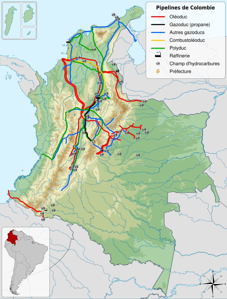
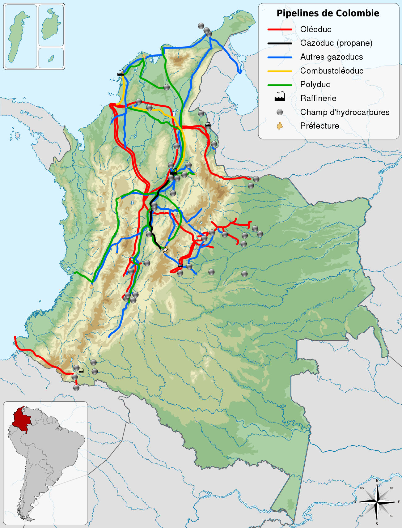
| 21:52, 11 February 2011 |  | 1,301 × 1,708 (1.13 MB) | Sémhur | == {{int:filedesc}} == {{Information |Description={{Multilingual description |en= Map of pipelines of Colombia. |es= Mapa de los transportes por tubería de Colombia. |fr= Carte des pipelines de Colombie. |
File usage
The following pages on the English Wikipedia use this file (pages on other projects are not listed):
Global file usage
The following other wikis use this file:
- Usage on fr.wikipedia.org