Climatic_zones_and_antipodes.png (180 × 180 pixels, file size: 31 KB, MIME type: image/png)
| This is a file from the Wikimedia Commons. Information from its description page there is shown below. Commons is a freely licensed media file repository. You can help. |
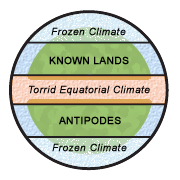
Summary
Diagram illustrating the classical climatic zones. The torrid (and "unhabitable") climatic zone of the equator is in red, the cold (and "unhabitable") climatic zones at the poles are in white/blue.
"Dating back to classical times, most people thought of the world as divided into zones of climate: a frozen climate at the poles, a torrid climate at the equator, and a blissfully mild (and therefore habitable) climate in between. They logically connected the temperature difference of these zones with proximity to the sun, and to a large extent they were right. Where they were wrong, however, was in their belief that the cold and torrid zones were impassable." [1] archive copy at the Wayback Machine
This image was made by Leinad-Z. Based on Image:Mappaemundi vertical.gif by John Hamer and inspired by images from Macrobius' Commentarii in Somnium Scipionis. More specifically, the picture is related with the two diagrams below.
-
 The five climatic zones of the earth.
 -
 Figure of the Earth from Macrobius.


Licensing
- You are free:
- to share – to copy, distribute and transmit the work
- to remix – to adapt the work
- Under the following conditions:
- attribution – You must give appropriate credit, provide a link to the license, and indicate if changes were made. You may do so in any reasonable manner, but not in any way that suggests the licensor endorses you or your use.

|
This geology image could be re-created using vector graphics as an SVG file. This has several advantages; see Commons:Media for cleanup for more information. If an SVG form of this image is available, please upload it and afterwards replace this template with
{{vector version available|new image name}}.
It is recommended to name the SVG file “Climatic zones and antipodes.svg”—then the template Vector version available (or Vva) does not need the new image name parameter. |
File history
Click on a date/time to view the file as it appeared at that time.
| Date/Time | Thumbnail | Dimensions | User | Comment | |
|---|---|---|---|---|---|
| current | 21:25, 18 August 2006 | | 180 × 180 (31 KB) | Leinad-Z~commonswiki | "Texturized" version. |
| 21:23, 18 August 2006 |  | 180 × 180 (12 KB) | Leinad-Z~commonswiki | New colors and text position. | |
| 19:44, 17 August 2006 |  | 180 × 180 (12 KB) | Leinad-Z~commonswiki | Made by by Leinad-Z. Based on Image:Mappaemundi vertical.gif by John Hamer. |
File usage
Global file usage
The following other wikis use this file:
- Usage on ar.wikipedia.org
- Usage on es.wikipedia.org
- Usage on hu.wikipedia.org
- Usage on no.wikipedia.org