
Size of this PNG preview of this SVG file: 417 × 565 pixels. Other resolutions: 177 × 240 pixels | 354 × 480 pixels | 567 × 768 pixels | 756 × 1,024 pixels | 1,511 × 2,048 pixels.
Original file (SVG file, nominally 417 × 565 pixels, file size: 78 KB)
| This is a file from the Wikimedia Commons. Information from its description page there is shown below. Commons is a freely licensed media file repository. You can help. |
Summary
| Description |
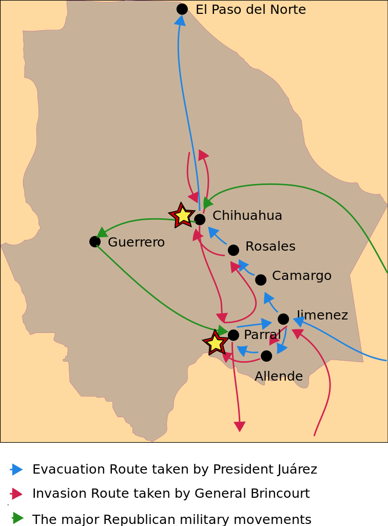
English: Map of military movements within the state of Chihuahua during the French Intervention |
| Date | |
| Source | Own work |
| Author | Ricraider |
Licensing
I, the copyright holder of this work, hereby publish it under the following license:
| This file is made available under the Creative Commons CC0 1.0 Universal Public Domain Dedication. | |
| The person who associated a work with this deed has dedicated the work to the public domain by waiving all of their rights to the work worldwide under copyright law, including all related and neighboring rights, to the extent allowed by law. You can copy, modify, distribute and perform the work, even for commercial purposes, all without asking permission.
|
File history
Click on a date/time to view the file as it appeared at that time.
| Date/Time | Thumbnail | Dimensions | User | Comment | |
|---|---|---|---|---|---|
| current | 10:29, 17 January 2011 | | 417 × 565 (78 KB) | Ricraider | cropping |
| 10:00, 17 January 2011 |  | 471 × 847 (27 KB) | Ricraider | {{Information |Description={{en|1=Map of military movements within the state of Chihuahua during the French Intervention}} |Source={{own}} |Author=Ricraider |Date=2011-01-17 |Permission= |other_versions= }} Category:Chihuahua |
File usage
The following pages on the English Wikipedia use this file (pages on other projects are not listed):
Global file usage
The following other wikis use this file:
- Usage on ro.wikipedia.org
- Chihuahua (stat)
- Madrean Sky Islands
- Lista grupelor montane ce formează Madrean Sky Islands
- Categorie:Madrean Sky Islands
- Categorie:Regiuni ale statului Chihuahua
- Categorie:Statul Chihuahua, Mexic
- Chihuahua, Chihuahua
- Deșertul Chihuahua
- Categorie:Geografia statului Chihuahua, Mexic
- Moctezuma, Chihuahua
- Categorie:Deșerturi ale statului Chihuahua, Mexic
- Format:Chihuahua stat Mexic
- Solferino (Chihuahua)
- Casas Grandes, Chihuahua
- Categorie:Localități din statul Chihuahua
- Usage on uk.wikipedia.org